You are here: Home > Network List > TA - USArray Transportable Network (new EarthScope stations) Stations List
> Station V28A Channing, TX, USA > Earthquake Result Viewer
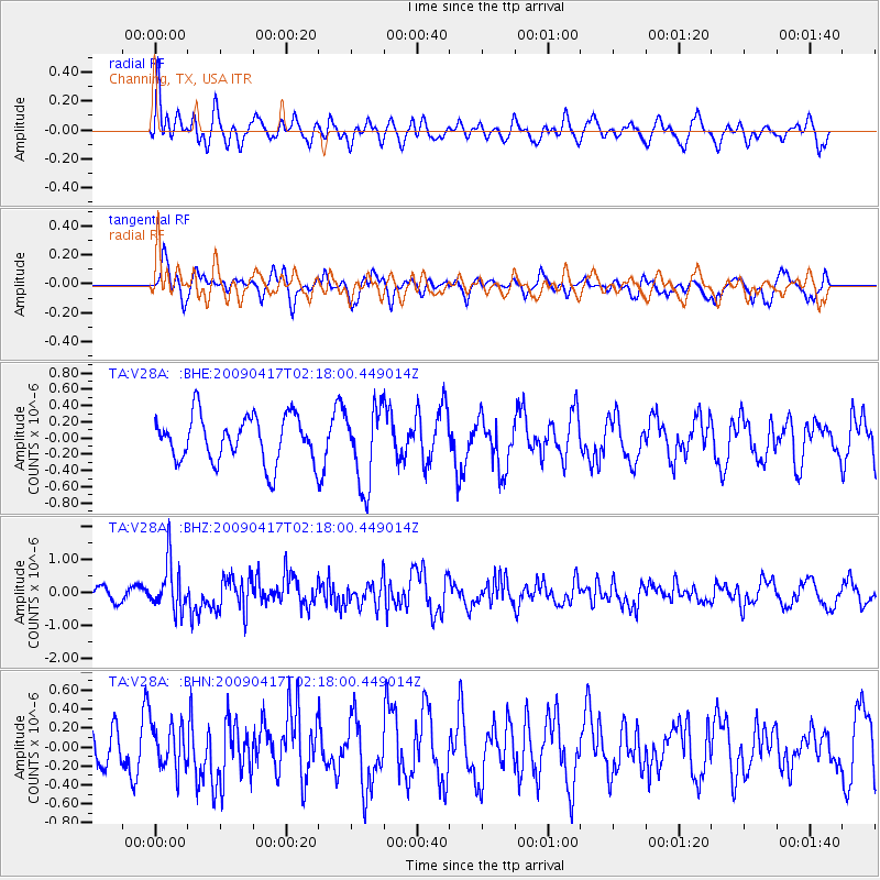
V28A Channing, TX, USA - Earthquake Result Viewer
*The percent match for this event was below the threshold and hence no stack was calculated.
| Earthquake location: |
Near Coast Of Northern Chile |
| Earthquake latitude/longitude: |
-19.6/-70.5 |
| Earthquake time(UTC): |
2009/04/17 (107) 02:08:08 GMT |
| Earthquake Depth: |
25 km |
| Earthquake Magnitude: |
5.8 MB, 5.8 MS, 6.1 MW, 6.1 MW |
| Earthquake Catalog/Contributor: |
WHDF/NEIC |
|
| Network: |
TA USArray Transportable Network (new EarthScope stations) |
| Station: |
V28A Channing, TX, USA |
| Lat/Lon: |
35.75 N/102.22 W |
| Elevation: |
1163 m |
|
| Distance: |
62.7 deg |
| Az: |
331.216 deg |
| Baz: |
146.074 deg |
| Ray Param: |
$rayparam |
*The percent match for this event was below the threshold and hence was not used in the summary stack. |
|
| Radial Match: |
69.45767 % |
| Radial Bump: |
400 |
| Transverse Match: |
51.057816 % |
| Transverse Bump: |
351 |
| SOD ConfigId: |
2658 |
| Insert Time: |
2010-03-05 23:00:45.314 +0000 |
| GWidth: |
2.5 |
| Max Bumps: |
400 |
| Tol: |
0.001 |
|
Signal To Noise
| Channel | StoN | STA | LTA |
| TA:V28A: :BHZ:20090417T02:18:00.449014Z | 5.190451 | 7.332687E-7 | 1.4127262E-7 |
| TA:V28A: :BHN:20090417T02:18:00.449014Z | 0.93002015 | 2.3717851E-7 | 2.5502513E-7 |
| TA:V28A: :BHE:20090417T02:18:00.449014Z | 1.7140257 | 4.842904E-7 | 2.8254559E-7 |
| Arrivals |
| Ps | |
| PpPs | |
| PsPs/PpSs | |


