You are here: Home > Network List > N4 - Central and EAstern US Network Stations List
> Station M50A Fremont, OH, USA > Earthquake Result Viewer
M50A Fremont, OH, USA - Earthquake Result Viewer
| Earthquake location: |
Chile-Argentina Border Region |
| Earthquake latitude/longitude: |
-23.2/-67.7 |
| Earthquake time(UTC): |
2017/04/15 (105) 08:19:41 GMT |
| Earthquake Depth: |
135 km |
| Earthquake Magnitude: |
6.2 Mww |
| Earthquake Catalog/Contributor: |
NEIC PDE/us |
|
| Network: |
N4 Central and EAstern US Network |
| Station: |
M50A Fremont, OH, USA |
| Lat/Lon: |
41.40 N/83.04 W |
| Elevation: |
176 m |
|
| Distance: |
65.9 deg |
| Az: |
347.364 deg |
| Baz: |
164.486 deg |
| Ray Param: |
0.057608522 |
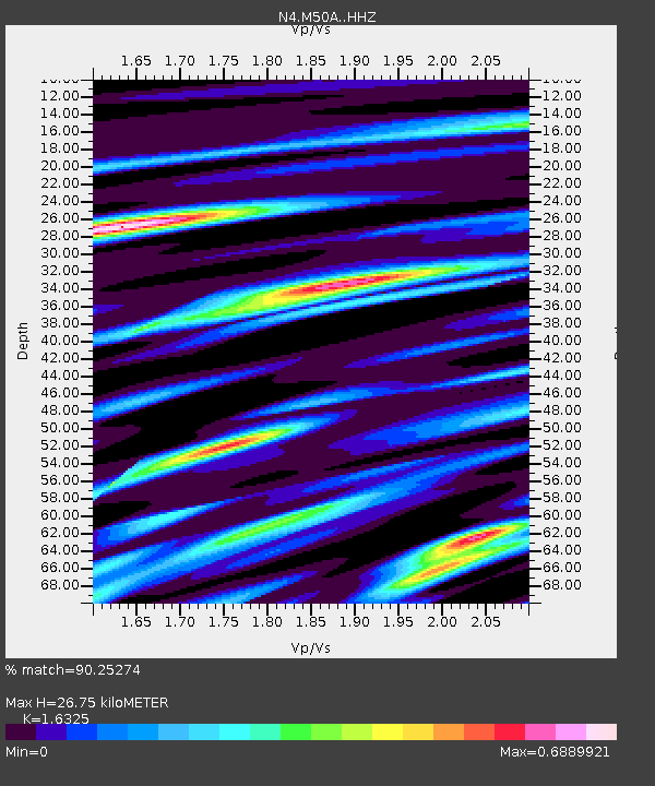
| Estimated Moho Depth: |
26.75 km |
| Estimated Crust Vp/Vs: |
1.63 |
| Assumed Crust Vp: |
6.498 km/s |
| Estimated Crust Vs: |
3.98 km/s |
| Estimated Crust Poisson's Ratio: |
0.20 |
|
| Radial Match: |
90.25274 % |
| Radial Bump: |
324 |
| Transverse Match: |
72.27273 % |
| Transverse Bump: |
400 |
| SOD ConfigId: |
11737051 |
| Insert Time: |
2019-04-27 02:51:38.047 +0000 |
| GWidth: |
2.5 |
| Max Bumps: |
400 |
| Tol: |
0.001 |
|

Signal To Noise
| Channel | StoN | STA | LTA |
| N4:M50A: :HHZ:20170415T08:29:41.670017Z | 11.540105 | 1.479372E-6 | 1.2819399E-7 |
| N4:M50A: :HHN:20170415T08:29:41.670017Z | 4.7088804 | 7.453482E-7 | 1.5828566E-7 |
| N4:M50A: :HHE:20170415T08:29:41.670017Z | 1.7337548 | 2.940956E-7 | 1.696293E-7 |
| Arrivals |
| Ps | 2.7 SECOND |
| PpPs | 10 SECOND |
| PsPs/PpSs | 13 SECOND |


