You are here: Home > Network List > CI - Caltech Regional Seismic Network Stations List
> Station DAN Danby, California, USA > Earthquake Result Viewer
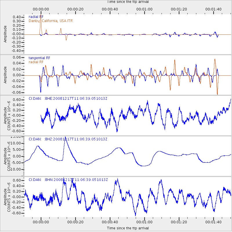
DAN Danby, California, USA - Earthquake Result Viewer
*The percent match for this event was below the threshold and hence no stack was calculated.
| Earthquake location: |
Fiji Islands Region |
| Earthquake latitude/longitude: |
-17.7/-178.4 |
| Earthquake time(UTC): |
2008/12/17 (352) 10:55:59 GMT |
| Earthquake Depth: |
530 km |
| Earthquake Magnitude: |
5.8 MW, 5.2 MB, 5.8 MW |
| Earthquake Catalog/Contributor: |
WHDF/NEIC |
|
| Network: |
CI Caltech Regional Seismic Network |
| Station: |
DAN Danby, California, USA |
| Lat/Lon: |
34.64 N/115.38 W |
| Elevation: |
398 m |
|
| Distance: |
79.3 deg |
| Az: |
48.382 deg |
| Baz: |
239.776 deg |
| Ray Param: |
$rayparam |
*The percent match for this event was below the threshold and hence was not used in the summary stack. |
|
| Radial Match: |
60.748943 % |
| Radial Bump: |
400 |
| Transverse Match: |
64.87356 % |
| Transverse Bump: |
400 |
| SOD ConfigId: |
2658 |
| Insert Time: |
2010-02-26 01:06:36.987 +0000 |
| GWidth: |
2.5 |
| Max Bumps: |
400 |
| Tol: |
0.001 |
|
Signal To Noise
| Channel | StoN | STA | LTA |
| CI:DAN: :BHZ:20081217T11:06:39.051013Z | 2.1541939 | 5.1789552E-6 | 2.404127E-6 |
| CI:DAN: :BHN:20081217T11:06:39.051013Z | 0.61994565 | 1.4078799E-7 | 2.2709729E-7 |
| CI:DAN: :BHE:20081217T11:06:39.051013Z | 1.1954495 | 2.5312562E-7 | 2.1174095E-7 |
| Arrivals |
| Ps | |
| PpPs | |
| PsPs/PpSs | |


