You are here: Home > Network List > N4 - Central and EAstern US Network Stations List
> Station U56A King, NC, USA > Earthquake Result Viewer
U56A King, NC, USA - Earthquake Result Viewer
| Earthquake location: |
Chile-Argentina Border Region |
| Earthquake latitude/longitude: |
-23.2/-67.7 |
| Earthquake time(UTC): |
2017/04/15 (105) 08:19:41 GMT |
| Earthquake Depth: |
135 km |
| Earthquake Magnitude: |
6.2 Mww |
| Earthquake Catalog/Contributor: |
NEIC PDE/us |
|
| Network: |
N4 Central and EAstern US Network |
| Station: |
U56A King, NC, USA |
| Lat/Lon: |
36.35 N/80.38 W |
| Elevation: |
363 m |
|
| Distance: |
60.5 deg |
| Az: |
348.202 deg |
| Baz: |
166.529 deg |
| Ray Param: |
0.061102714 |
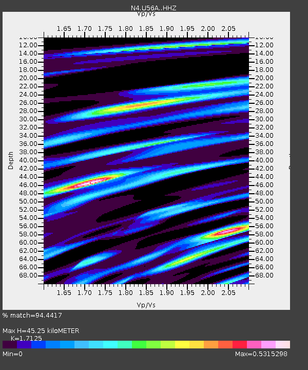
| Estimated Moho Depth: |
45.25 km |
| Estimated Crust Vp/Vs: |
1.71 |
| Assumed Crust Vp: |
6.159 km/s |
| Estimated Crust Vs: |
3.596 km/s |
| Estimated Crust Poisson's Ratio: |
0.24 |
|
| Radial Match: |
94.4417 % |
| Radial Bump: |
217 |
| Transverse Match: |
78.54446 % |
| Transverse Bump: |
400 |
| SOD ConfigId: |
11737051 |
| Insert Time: |
2019-04-27 02:52:21.369 +0000 |
| GWidth: |
2.5 |
| Max Bumps: |
400 |
| Tol: |
0.001 |
|

Signal To Noise
| Channel | StoN | STA | LTA |
| N4:U56A: :HHZ:20170415T08:29:06.170017Z | 22.938997 | 3.3643803E-6 | 1.4666641E-7 |
| N4:U56A: :HHN:20170415T08:29:06.170017Z | 21.644388 | 1.8835896E-6 | 8.702438E-8 |
| N4:U56A: :HHE:20170415T08:29:06.170017Z | 6.476124 | 5.1934285E-7 | 8.019347E-8 |
| Arrivals |
| Ps | 5.5 SECOND |
| PpPs | 19 SECOND |
| PsPs/PpSs | 25 SECOND |


