You are here: Home > Network List > TA - USArray Transportable Network (new EarthScope stations) Stations List
> Station V28A Channing, TX, USA > Earthquake Result Viewer
V28A Channing, TX, USA - Earthquake Result Viewer
*The percent match for this event was below the threshold and hence no stack was calculated.
| Earthquake location: |
Hokkaido, Japan Region |
| Earthquake latitude/longitude: |
42.6/142.1 |
| Earthquake time(UTC): |
2009/02/28 (059) 00:35:56 GMT |
| Earthquake Depth: |
105 km |
| Earthquake Magnitude: |
5.5 MB, 5.5 MW, 5.5 MW |
| Earthquake Catalog/Contributor: |
WHDF/NEIC |
|
| Network: |
TA USArray Transportable Network (new EarthScope stations) |
| Station: |
V28A Channing, TX, USA |
| Lat/Lon: |
35.75 N/102.22 W |
| Elevation: |
1163 m |
|
| Distance: |
82.4 deg |
| Az: |
47.699 deg |
| Baz: |
317.835 deg |
| Ray Param: |
$rayparam |
*The percent match for this event was below the threshold and hence was not used in the summary stack. |
|
| Radial Match: |
44.531597 % |
| Radial Bump: |
400 |
| Transverse Match: |
68.36345 % |
| Transverse Bump: |
400 |
| SOD ConfigId: |
2658 |
| Insert Time: |
2010-03-05 23:01:06.394 +0000 |
| GWidth: |
2.5 |
| Max Bumps: |
400 |
| Tol: |
0.001 |
|
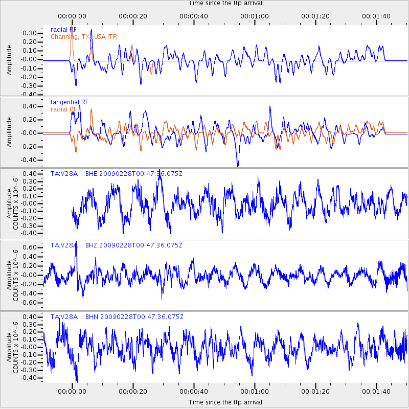
Signal To Noise
| Channel | StoN | STA | LTA |
| TA:V28A: :BHZ:20090228T00:47:36.075Z | 2.0293999 | 2.730149E-7 | 1.3452987E-7 |
| TA:V28A: :BHN:20090228T00:47:36.075Z | 1.0942472 | 1.9917364E-7 | 1.8201888E-7 |
| TA:V28A: :BHE:20090228T00:47:36.075Z | 1.1634178 | 1.9144932E-7 | 1.6455766E-7 |
| Arrivals |
| Ps | |
| PpPs | |
| PsPs/PpSs | |


