You are here: Home > Network List > TA - USArray Transportable Network (new EarthScope stations) Stations List
> Station V28A Channing, TX, USA > Earthquake Result Viewer
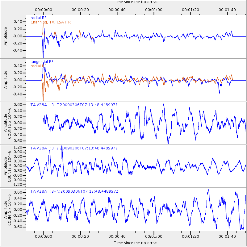
V28A Channing, TX, USA - Earthquake Result Viewer
*The percent match for this event was below the threshold and hence no stack was calculated.
| Earthquake location: |
Tonga Islands |
| Earthquake latitude/longitude: |
-15.2/-173.3 |
| Earthquake time(UTC): |
2009/03/06 (065) 07:01:48 GMT |
| Earthquake Depth: |
3.0 km |
| Earthquake Magnitude: |
5.5 MB, 5.4 MS, 5.8 MW, 5.8 MW |
| Earthquake Catalog/Contributor: |
WHDF/NEIC |
|
| Network: |
TA USArray Transportable Network (new EarthScope stations) |
| Station: |
V28A Channing, TX, USA |
| Lat/Lon: |
35.75 N/102.22 W |
| Elevation: |
1163 m |
|
| Distance: |
84.1 deg |
| Az: |
50.683 deg |
| Baz: |
246.7 deg |
| Ray Param: |
$rayparam |
*The percent match for this event was below the threshold and hence was not used in the summary stack. |
|
| Radial Match: |
56.04476 % |
| Radial Bump: |
400 |
| Transverse Match: |
59.480392 % |
| Transverse Bump: |
400 |
| SOD ConfigId: |
2658 |
| Insert Time: |
2010-03-05 23:01:08.403 +0000 |
| GWidth: |
2.5 |
| Max Bumps: |
400 |
| Tol: |
0.001 |
|
Signal To Noise
| Channel | StoN | STA | LTA |
| TA:V28A: :BHZ:20090306T07:13:48.448997Z | 2.5263216 | 4.871681E-7 | 1.9283692E-7 |
| TA:V28A: :BHN:20090306T07:13:48.448997Z | 0.9113167 | 2.2278199E-7 | 2.4446166E-7 |
| TA:V28A: :BHE:20090306T07:13:48.448997Z | 1.5815766 | 2.034724E-7 | 1.2865162E-7 |
| Arrivals |
| Ps | |
| PpPs | |
| PsPs/PpSs | |


