You are here: Home > Network List > N4 - Central and EAstern US Network Stations List
> Station Y58A Scranton, SC, USA > Earthquake Result Viewer
Y58A Scranton, SC, USA - Earthquake Result Viewer
| Earthquake location: |
Chile-Argentina Border Region |
| Earthquake latitude/longitude: |
-23.2/-67.7 |
| Earthquake time(UTC): |
2017/04/15 (105) 08:19:41 GMT |
| Earthquake Depth: |
135 km |
| Earthquake Magnitude: |
6.2 Mww |
| Earthquake Catalog/Contributor: |
NEIC PDE/us |
|
| Network: |
N4 Central and EAstern US Network |
| Station: |
Y58A Scranton, SC, USA |
| Lat/Lon: |
33.91 N/79.67 W |
| Elevation: |
19 m |
|
| Distance: |
58.0 deg |
| Az: |
348.217 deg |
| Baz: |
166.947 deg |
| Ray Param: |
0.06273614 |
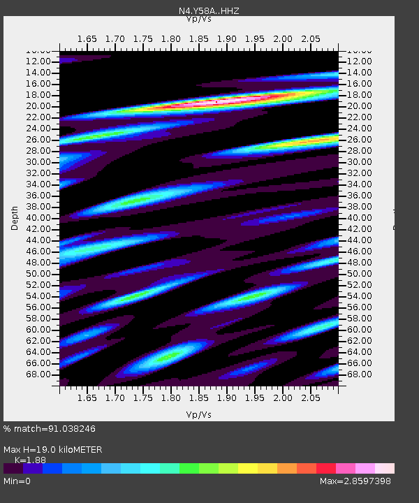
| Estimated Moho Depth: |
19.0 km |
| Estimated Crust Vp/Vs: |
1.88 |
| Assumed Crust Vp: |
6.24 km/s |
| Estimated Crust Vs: |
3.319 km/s |
| Estimated Crust Poisson's Ratio: |
0.30 |
|
| Radial Match: |
91.038246 % |
| Radial Bump: |
341 |
| Transverse Match: |
79.13234 % |
| Transverse Bump: |
340 |
| SOD ConfigId: |
11737051 |
| Insert Time: |
2019-04-27 02:52:38.050 +0000 |
| GWidth: |
2.5 |
| Max Bumps: |
400 |
| Tol: |
0.001 |
|

Signal To Noise
| Channel | StoN | STA | LTA |
| N4:Y58A: :HHZ:20170415T08:28:48.990024Z | 20.664742 | 3.6649374E-6 | 1.773522E-7 |
| N4:Y58A: :HHN:20170415T08:28:48.990024Z | 11.930549 | 5.041523E-6 | 4.2257258E-7 |
| N4:Y58A: :HHE:20170415T08:28:48.990024Z | 4.796858 | 1.3667099E-6 | 2.8491772E-7 |
| Arrivals |
| Ps | 2.8 SECOND |
| PpPs | 8.4 SECOND |
| PsPs/PpSs | 11 SECOND |


