You are here: Home > Network List > TA - USArray Transportable Network (new EarthScope stations) Stations List
> Station V28A Channing, TX, USA > Earthquake Result Viewer
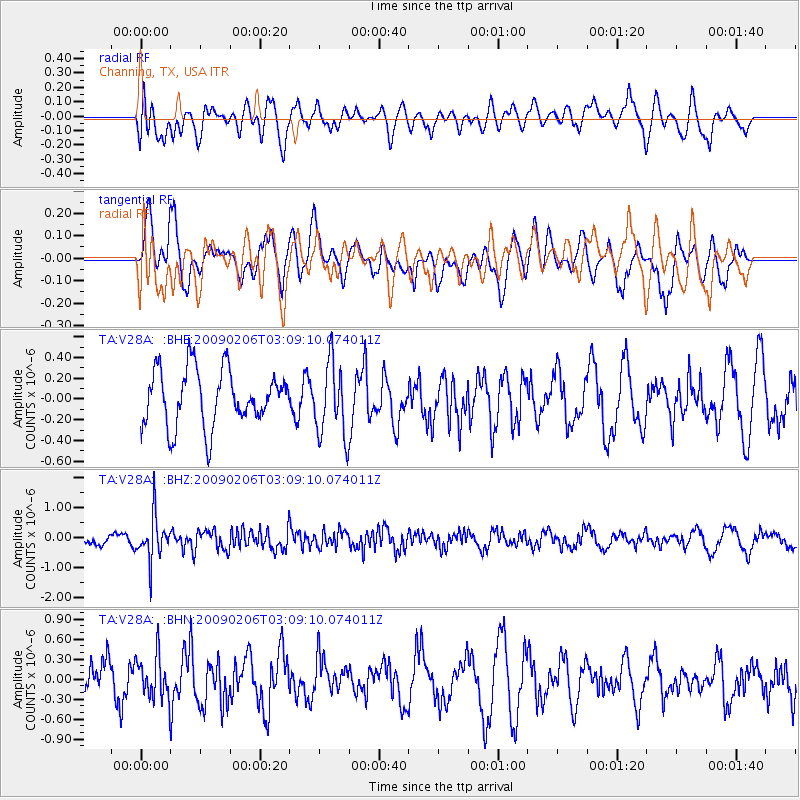
V28A Channing, TX, USA - Earthquake Result Viewer
*The percent match for this event was below the threshold and hence no stack was calculated.
| Earthquake location: |
Near Coast Of Northern Chile |
| Earthquake latitude/longitude: |
-28.0/-71.1 |
| Earthquake time(UTC): |
2009/02/06 (037) 02:58:35 GMT |
| Earthquake Depth: |
52 km |
| Earthquake Magnitude: |
5.5 MB |
| Earthquake Catalog/Contributor: |
WHDF/NEIC |
|
| Network: |
TA USArray Transportable Network (new EarthScope stations) |
| Station: |
V28A Channing, TX, USA |
| Lat/Lon: |
35.75 N/102.22 W |
| Elevation: |
1163 m |
|
| Distance: |
69.9 deg |
| Az: |
333.398 deg |
| Baz: |
150.868 deg |
| Ray Param: |
$rayparam |
*The percent match for this event was below the threshold and hence was not used in the summary stack. |
|
| Radial Match: |
50.48113 % |
| Radial Bump: |
400 |
| Transverse Match: |
61.547077 % |
| Transverse Bump: |
400 |
| SOD ConfigId: |
2658 |
| Insert Time: |
2010-03-05 23:01:18.441 +0000 |
| GWidth: |
2.5 |
| Max Bumps: |
400 |
| Tol: |
0.001 |
|
Signal To Noise
| Channel | StoN | STA | LTA |
| TA:V28A: :BHZ:20090206T03:09:10.074011Z | 2.944642 | 7.29749E-7 | 2.4782267E-7 |
| TA:V28A: :BHN:20090206T03:09:10.074011Z | 1.6058801 | 3.2105214E-7 | 1.9992285E-7 |
| TA:V28A: :BHE:20090206T03:09:10.074011Z | 1.3434606 | 3.5961955E-7 | 2.6768151E-7 |
| Arrivals |
| Ps | |
| PpPs | |
| PsPs/PpSs | |


