You are here: Home > Network List > CO - South Carolina Seismic Network Stations List
> Station SUMMV Summerville Airport, SC, USA > Earthquake Result Viewer
SUMMV Summerville Airport, SC, USA - Earthquake Result Viewer
| Earthquake location: |
Peru-Brazil Border Region |
| Earthquake latitude/longitude: |
-10.6/-71.0 |
| Earthquake time(UTC): |
2015/11/24 (328) 22:45:38 GMT |
| Earthquake Depth: |
602 km |
| Earthquake Magnitude: |
7.5 MWW, 6.9 MI |
| Earthquake Catalog/Contributor: |
NEIC PDE/NEIC COMCAT |
|
| Network: |
CO South Carolina Seismic Network |
| Station: |
SUMMV Summerville Airport, SC, USA |
| Lat/Lon: |
33.07 N/80.27 W |
| Elevation: |
17 m |
|
| Distance: |
44.3 deg |
| Az: |
348.787 deg |
| Baz: |
166.839 deg |
| Ray Param: |
0.06895587 |
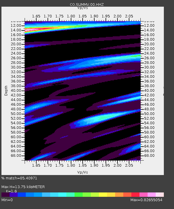
| Estimated Moho Depth: |
13.75 km |
| Estimated Crust Vp/Vs: |
1.60 |
| Assumed Crust Vp: |
6.565 km/s |
| Estimated Crust Vs: |
4.103 km/s |
| Estimated Crust Poisson's Ratio: |
0.18 |
|
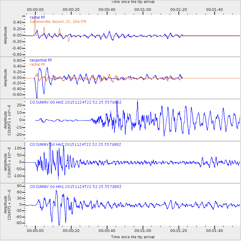
| Radial Match: |
85.40971 % |
| Radial Bump: |
363 |
| Transverse Match: |
89.17536 % |
| Transverse Bump: |
265 |
| SOD ConfigId: |
1259291 |
| Insert Time: |
2015-12-08 23:32:20.750 +0000 |
| GWidth: |
2.5 |
| Max Bumps: |
400 |
| Tol: |
0.001 |
|
Signal To Noise
| Channel | StoN | STA | LTA |
| CO:SUMMV:00:HHZ:20151124T22:52:25.557986Z | 55.75741 | 2.7454033E-5 | 4.923836E-7 |
| CO:SUMMV:00:HH1:20151124T22:52:25.557986Z | 13.009731 | 1.4011399E-5 | 1.0769937E-6 |
| CO:SUMMV:00:HH2:20151124T22:52:25.557986Z | 1.6089656 | 1.5015235E-6 | 9.3322285E-7 |
| Arrivals |
| Ps | 1.3 SECOND |
| PpPs | 5.1 SECOND |
| PsPs/PpSs | 6.4 SECOND |


