You are here: Home > Network List > PE - Penn State Network Stations List
> Station PAPL Promised Land State Park, Greentown, PA > Earthquake Result Viewer
PAPL Promised Land State Park, Greentown, PA - Earthquake Result Viewer
| Earthquake location: |
Chile-Argentina Border Region |
| Earthquake latitude/longitude: |
-23.2/-67.7 |
| Earthquake time(UTC): |
2017/04/15 (105) 08:19:41 GMT |
| Earthquake Depth: |
135 km |
| Earthquake Magnitude: |
6.2 Mww |
| Earthquake Catalog/Contributor: |
NEIC PDE/us |
|
| Network: |
PE Penn State Network |
| Station: |
PAPL Promised Land State Park, Greentown, PA |
| Lat/Lon: |
41.30 N/75.02 W |
| Elevation: |
572 m |
|
| Distance: |
64.6 deg |
| Az: |
353.857 deg |
| Baz: |
172.494 deg |
| Ray Param: |
0.05845934 |
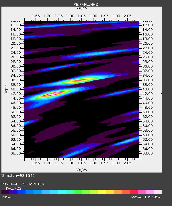
| Estimated Moho Depth: |
41.75 km |
| Estimated Crust Vp/Vs: |
1.73 |
| Assumed Crust Vp: |
6.283 km/s |
| Estimated Crust Vs: |
3.643 km/s |
| Estimated Crust Poisson's Ratio: |
0.25 |
|
| Radial Match: |
93.1542 % |
| Radial Bump: |
237 |
| Transverse Match: |
81.073425 % |
| Transverse Bump: |
400 |
| SOD ConfigId: |
11737051 |
| Insert Time: |
2019-04-27 02:54:51.502 +0000 |
| GWidth: |
2.5 |
| Max Bumps: |
400 |
| Tol: |
0.001 |
|

Signal To Noise
| Channel | StoN | STA | LTA |
| PE:PAPL: :HHZ:20170415T08:29:33.35001Z | 13.916126 | 1.4336802E-6 | 1.0302293E-7 |
| PE:PAPL: :HHN:20170415T08:29:33.35001Z | 12.348226 | 5.9431477E-7 | 4.8129568E-8 |
| PE:PAPL: :HHE:20170415T08:29:33.35001Z | 1.5593729 | 1.6244189E-7 | 1.04171285E-7 |
| Arrivals |
| Ps | 5.0 SECOND |
| PpPs | 17 SECOND |
| PsPs/PpSs | 22 SECOND |


