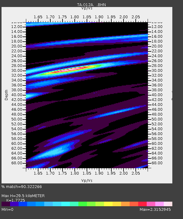
O12A Currie, NV, USA - Earthquake Result Viewer

Earthquake location: Andreanof Islands, Aleutian Is.
Earthquake latitude/longitude: 51.9/-179.4
Earthquake time(UTC): 2008/04/15 (106) 22:59:51 GMT
Earthquake Depth: 10 km
Earthquake Magnitude: 6.1 MB, 6.4 MS, 6.4 MW, 6.4 MW
Earthquake Catalog/Contributor: WHDF/NEIC
Network: TA USArray Transportable Network (new EarthScope stations)
Station: O12A Currie, NV, USA
Lat/Lon: 40.27 N/114.75 W
Elevation: 1743 m
Distance: 44.9 deg
Az: 78.392 deg
Baz: 307.438 deg
Ray Param: 0.071640395
Estimated Moho Depth: 29.5 km
Estimated Crust Vp/Vs: 1.77
Assumed Crust Vp: 6.276 km/s
Estimated Crust Vs: 3.541 km/s
Estimated Crust Poisson's Ratio: 0.27
Radial Match: 90.322266 %
Radial Bump: 366
Transverse Match: 86.73483 %
Transverse Bump: 400
SOD ConfigId: 2504
Insert Time: 2010-03-05 23:01:33.354 +0000
GWidth: 2.5
Max Bumps: 400
Tol: 0.001

Signal To Noise

ChannelStoNSTALTA
TA:O12A: :BHN:20080415T23:07:35.024011Z14.1425261.9180575E-61.3562341E-7
TA:O12A: :BHE:20080415T23:07:35.024011Z8.2663927.195418E-78.704424E-8
TA:O12A: :BHZ:20080415T23:07:35.024011Z3.28469169.0556324E-72.75692E-7
Arrivals
Ps3.9 SECOND
PpPs12 SECOND
PsPs/PpSs16 SECOND