You are here: Home > Network List > TA - USArray Transportable Network (new EarthScope stations) Stations List
> Station P52A Corning, OH, USA > Earthquake Result Viewer
P52A Corning, OH, USA - Earthquake Result Viewer
| Earthquake location: |
Chile-Argentina Border Region |
| Earthquake latitude/longitude: |
-23.2/-67.7 |
| Earthquake time(UTC): |
2017/04/15 (105) 08:19:41 GMT |
| Earthquake Depth: |
135 km |
| Earthquake Magnitude: |
6.2 Mww |
| Earthquake Catalog/Contributor: |
NEIC PDE/us |
|
| Network: |
TA USArray Transportable Network (new EarthScope stations) |
| Station: |
P52A Corning, OH, USA |
| Lat/Lon: |
39.63 N/82.13 W |
| Elevation: |
293 m |
|
| Distance: |
64.0 deg |
| Az: |
347.593 deg |
| Baz: |
165.172 deg |
| Ray Param: |
0.05883253 |
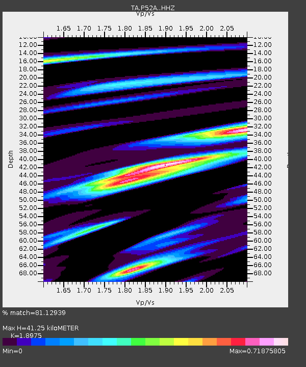
| Estimated Moho Depth: |
41.25 km |
| Estimated Crust Vp/Vs: |
1.90 |
| Assumed Crust Vp: |
6.232 km/s |
| Estimated Crust Vs: |
3.284 km/s |
| Estimated Crust Poisson's Ratio: |
0.31 |
|
| Radial Match: |
81.12939 % |
| Radial Bump: |
324 |
| Transverse Match: |
65.58477 % |
| Transverse Bump: |
394 |
| SOD ConfigId: |
11737051 |
| Insert Time: |
2019-04-27 02:56:24.784 +0000 |
| GWidth: |
2.5 |
| Max Bumps: |
400 |
| Tol: |
0.001 |
|

Signal To Noise
| Channel | StoN | STA | LTA |
| TA:P52A: :HHZ:20170415T08:29:29.519993Z | 15.635397 | 1.6579517E-6 | 1.0603835E-7 |
| TA:P52A: :HHN:20170415T08:29:29.519993Z | 5.7020526 | 6.7491897E-7 | 1.18364206E-7 |
| TA:P52A: :HHE:20170415T08:29:29.519993Z | 3.354689 | 2.658187E-7 | 7.9237964E-8 |
| Arrivals |
| Ps | 6.2 SECOND |
| PpPs | 18 SECOND |
| PsPs/PpSs | 25 SECOND |


