You are here: Home > Network List > TA - USArray Transportable Network (new EarthScope stations) Stations List
> Station SFIN Lafayette, IN, USA > Earthquake Result Viewer
SFIN Lafayette, IN, USA - Earthquake Result Viewer

| Earthquake location: |
Chile-Argentina Border Region |
| Earthquake latitude/longitude: |
-23.2/-67.7 |
| Earthquake time(UTC): |
2017/04/15 (105) 08:19:41 GMT |
| Earthquake Depth: |
135 km |
| Earthquake Magnitude: |
6.2 Mww |
| Earthquake Catalog/Contributor: |
NEIC PDE/us |
|
| Network: |
TA USArray Transportable Network (new EarthScope stations) |
| Station: |
SFIN Lafayette, IN, USA |
| Lat/Lon: |
40.38 N/87.10 W |
| Elevation: |
165 m |
|
| Distance: |
65.8 deg |
| Az: |
343.815 deg |
| Baz: |
160.389 deg |
| Ray Param: |
0.057639673 |
| Estimated Moho Depth: |
69.5 km |
| Estimated Crust Vp/Vs: |
1.71 |
| Assumed Crust Vp: |
6.498 km/s |
| Estimated Crust Vs: |
3.794 km/s |
| Estimated Crust Poisson's Ratio: |
0.24 |
|
| Radial Match: |
84.651085 % |
| Radial Bump: |
366 |
| Transverse Match: |
69.03342 % |
| Transverse Bump: |
400 |
| SOD ConfigId: |
11737051 |
| Insert Time: |
2019-04-27 02:56:29.369 +0000 |
| GWidth: |
2.5 |
| Max Bumps: |
400 |
| Tol: |
0.001 |
|
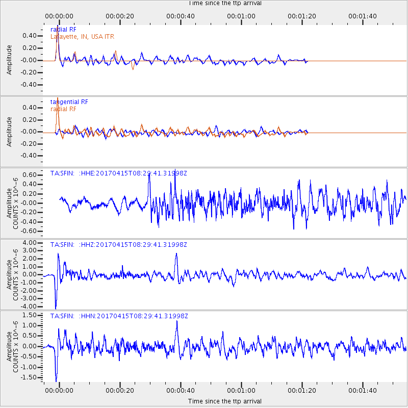
Signal To Noise
| Channel | StoN | STA | LTA |
| TA:SFIN: :HHZ:20170415T08:29:41.31998Z | 10.910168 | 1.2378708E-6 | 1.13460295E-7 |
| TA:SFIN: :HHN:20170415T08:29:41.31998Z | 6.226201 | 5.30425E-7 | 8.51924E-8 |
| TA:SFIN: :HHE:20170415T08:29:41.31998Z | 2.8321497 | 2.3882222E-7 | 8.432543E-8 |
| Arrivals |
| Ps | 8.0 SECOND |
| PpPs | 28 SECOND |
| PsPs/PpSs | 36 SECOND |


