You are here: Home > Network List > TA - USArray Transportable Network (new EarthScope stations) Stations List
> Station SUSD Miller, SD, USA > Earthquake Result Viewer
SUSD Miller, SD, USA - Earthquake Result Viewer
| Earthquake location: |
Chile-Argentina Border Region |
| Earthquake latitude/longitude: |
-23.2/-67.7 |
| Earthquake time(UTC): |
2017/04/15 (105) 08:19:41 GMT |
| Earthquake Depth: |
135 km |
| Earthquake Magnitude: |
6.2 Mww |
| Earthquake Catalog/Contributor: |
NEIC PDE/us |
|
| Network: |
TA USArray Transportable Network (new EarthScope stations) |
| Station: |
SUSD Miller, SD, USA |
| Lat/Lon: |
44.44 N/98.96 W |
| Elevation: |
520 m |
|
| Distance: |
73.2 deg |
| Az: |
337.122 deg |
| Baz: |
150.049 deg |
| Ray Param: |
0.052827712 |
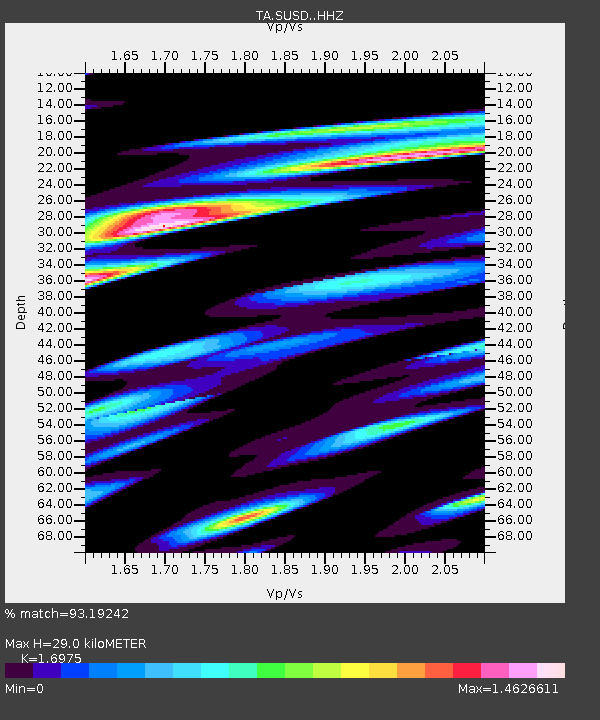
| Estimated Moho Depth: |
29.0 km |
| Estimated Crust Vp/Vs: |
1.70 |
| Assumed Crust Vp: |
6.53 km/s |
| Estimated Crust Vs: |
3.847 km/s |
| Estimated Crust Poisson's Ratio: |
0.23 |
|
| Radial Match: |
93.19242 % |
| Radial Bump: |
370 |
| Transverse Match: |
78.86438 % |
| Transverse Bump: |
400 |
| SOD ConfigId: |
11737051 |
| Insert Time: |
2019-04-27 02:56:31.394 +0000 |
| GWidth: |
2.5 |
| Max Bumps: |
400 |
| Tol: |
0.001 |
|

Signal To Noise
| Channel | StoN | STA | LTA |
| TA:SUSD: :HHZ:20170415T08:30:26.240024Z | 20.03342 | 1.9680597E-6 | 9.823882E-8 |
| TA:SUSD: :HHN:20170415T08:30:26.240024Z | 15.774589 | 1.964677E-6 | 1.2454696E-7 |
| TA:SUSD: :HHE:20170415T08:30:26.240024Z | 5.868775 | 7.944186E-7 | 1.353636E-7 |
| Arrivals |
| Ps | 3.2 SECOND |
| PpPs | 12 SECOND |
| PsPs/PpSs | 15 SECOND |


