You are here: Home > Network List > TA - USArray Transportable Network (new EarthScope stations) Stations List
> Station O12A Currie, NV, USA > Earthquake Result Viewer
O12A Currie, NV, USA - Earthquake Result Viewer
| Earthquake location: |
Kuril Islands |
| Earthquake latitude/longitude: |
46.5/153.3 |
| Earthquake time(UTC): |
2008/06/23 (175) 12:32:12 GMT |
| Earthquake Depth: |
10 km |
| Earthquake Magnitude: |
5.6 MB, 5.2 MS, 5.6 MW, 5.6 MW |
| Earthquake Catalog/Contributor: |
WHDF/NEIC |
|
| Network: |
TA USArray Transportable Network (new EarthScope stations) |
| Station: |
O12A Currie, NV, USA |
| Lat/Lon: |
40.27 N/114.75 W |
| Elevation: |
1743 m |
|
| Distance: |
63.4 deg |
| Az: |
58.748 deg |
| Baz: |
309.463 deg |
| Ray Param: |
0.059572287 |
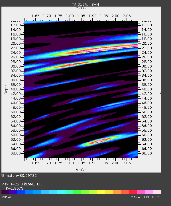
| Estimated Moho Depth: |
22.0 km |
| Estimated Crust Vp/Vs: |
1.96 |
| Assumed Crust Vp: |
6.276 km/s |
| Estimated Crust Vs: |
3.206 km/s |
| Estimated Crust Poisson's Ratio: |
0.32 |
|
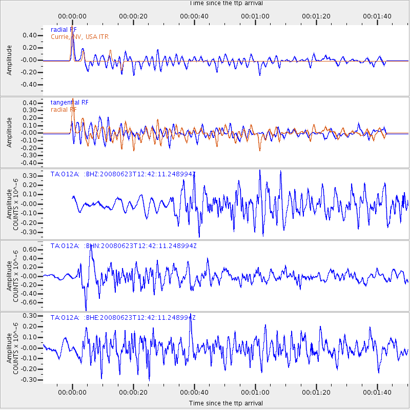
| Radial Match: |
80.29732 % |
| Radial Bump: |
400 |
| Transverse Match: |
78.57658 % |
| Transverse Bump: |
400 |
| SOD ConfigId: |
2504 |
| Insert Time: |
2010-03-05 23:01:50.158 +0000 |
| GWidth: |
2.5 |
| Max Bumps: |
400 |
| Tol: |
0.001 |
|
Signal To Noise
| Channel | StoN | STA | LTA |
| TA:O12A: :BHN:20080623T12:42:11.248994Z | 6.8431797 | 2.4684152E-7 | 3.607117E-8 |
| TA:O12A: :BHE:20080623T12:42:11.248994Z | 2.2459192 | 8.235374E-8 | 3.666817E-8 |
| TA:O12A: :BHZ:20080623T12:42:11.248994Z | 1.5178258 | 7.76079E-8 | 5.113096E-8 |
| Arrivals |
| Ps | 3.5 SECOND |
| PpPs | 10.0 SECOND |
| PsPs/PpSs | 13 SECOND |


