You are here: Home > Network List > TA - USArray Transportable Network (new EarthScope stations) Stations List
> Station O12A Currie, NV, USA > Earthquake Result Viewer
O12A Currie, NV, USA - Earthquake Result Viewer
| Earthquake location: |
Tonga Islands |
| Earthquake latitude/longitude: |
-20.8/-173.3 |
| Earthquake time(UTC): |
2008/06/26 (178) 21:19:15 GMT |
| Earthquake Depth: |
38 km |
| Earthquake Magnitude: |
6.0 MB, 5.8 MS, 6.2 MW, 6.1 MW |
| Earthquake Catalog/Contributor: |
WHDF/NEIC |
|
| Network: |
TA USArray Transportable Network (new EarthScope stations) |
| Station: |
O12A Currie, NV, USA |
| Lat/Lon: |
40.27 N/114.75 W |
| Elevation: |
1743 m |
|
| Distance: |
81.6 deg |
| Az: |
41.313 deg |
| Baz: |
233.843 deg |
| Ray Param: |
0.047418416 |
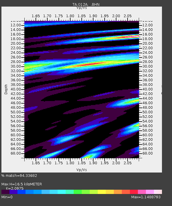
| Estimated Moho Depth: |
16.5 km |
| Estimated Crust Vp/Vs: |
2.10 |
| Assumed Crust Vp: |
6.276 km/s |
| Estimated Crust Vs: |
2.992 km/s |
| Estimated Crust Poisson's Ratio: |
0.35 |
|
| Radial Match: |
94.33682 % |
| Radial Bump: |
400 |
| Transverse Match: |
87.76377 % |
| Transverse Bump: |
400 |
| SOD ConfigId: |
2504 |
| Insert Time: |
2010-03-05 23:01:52.049 +0000 |
| GWidth: |
2.5 |
| Max Bumps: |
400 |
| Tol: |
0.001 |
|
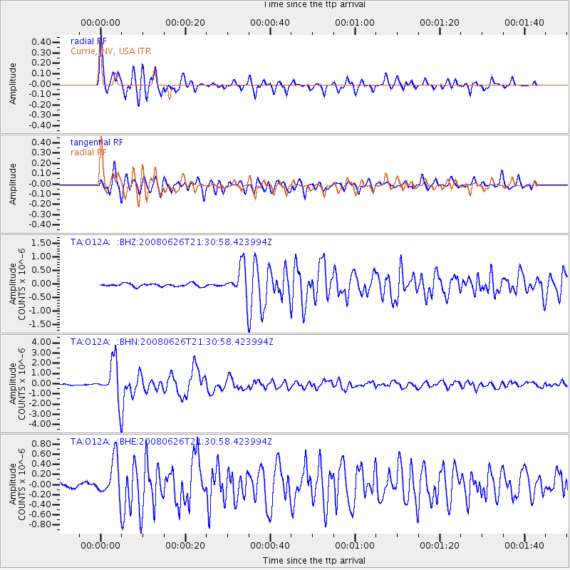
Signal To Noise
| Channel | StoN | STA | LTA |
| TA:O12A: :BHN:20080626T21:30:58.423994Z | 28.285685 | 1.9825454E-6 | 7.009007E-8 |
| TA:O12A: :BHE:20080626T21:30:58.423994Z | 8.302345 | 3.9243034E-7 | 4.726741E-8 |
| TA:O12A: :BHZ:20080626T21:30:58.423994Z | 10.919082 | 5.986092E-7 | 5.4822305E-8 |
| Arrivals |
| Ps | 2.9 SECOND |
| PpPs | 8.0 SECOND |
| PsPs/PpSs | 11 SECOND |


