You are here: Home > Network List > TA - USArray Transportable Network (new EarthScope stations) Stations List
> Station O12A Currie, NV, USA > Earthquake Result Viewer
O12A Currie, NV, USA - Earthquake Result Viewer
| Earthquake location: |
Eastern Honshu, Japan |
| Earthquake latitude/longitude: |
39.8/141.5 |
| Earthquake time(UTC): |
2008/07/23 (205) 15:26:19 GMT |
| Earthquake Depth: |
108 km |
| Earthquake Magnitude: |
6.6 MB, 6.8 MW, 6.8 MW |
| Earthquake Catalog/Contributor: |
WHDF/NEIC |
|
| Network: |
TA USArray Transportable Network (new EarthScope stations) |
| Station: |
O12A Currie, NV, USA |
| Lat/Lon: |
40.27 N/114.75 W |
| Elevation: |
1743 m |
|
| Distance: |
74.3 deg |
| Az: |
50.513 deg |
| Baz: |
309.011 deg |
| Ray Param: |
0.05214062 |
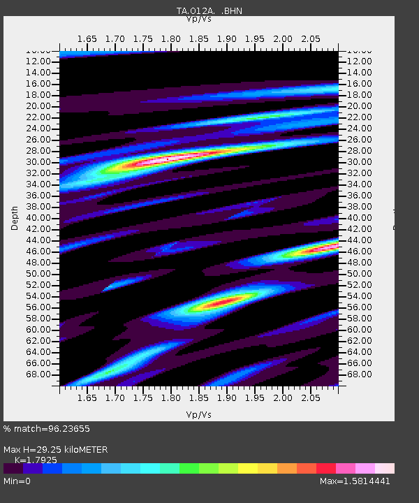
| Estimated Moho Depth: |
29.25 km |
| Estimated Crust Vp/Vs: |
1.79 |
| Assumed Crust Vp: |
6.276 km/s |
| Estimated Crust Vs: |
3.501 km/s |
| Estimated Crust Poisson's Ratio: |
0.27 |
|
| Radial Match: |
96.23655 % |
| Radial Bump: |
400 |
| Transverse Match: |
93.11087 % |
| Transverse Bump: |
400 |
| SOD ConfigId: |
2504 |
| Insert Time: |
2010-03-05 23:02:05.514 +0000 |
| GWidth: |
2.5 |
| Max Bumps: |
400 |
| Tol: |
0.001 |
|

Signal To Noise
| Channel | StoN | STA | LTA |
| TA:O12A: :BHN:20080723T15:37:14.775012Z | 37.198273 | 3.7849943E-6 | 1.0175189E-7 |
| TA:O12A: :BHE:20080723T15:37:14.775012Z | 11.575932 | 1.0109898E-6 | 8.73355E-8 |
| TA:O12A: :BHZ:20080723T15:37:14.775012Z | 10.900146 | 1.3914828E-6 | 1.2765726E-7 |
| Arrivals |
| Ps | 3.8 SECOND |
| PpPs | 13 SECOND |
| PsPs/PpSs | 16 SECOND |


