You are here: Home > Network List > TA - USArray Transportable Network (new EarthScope stations) Stations List
> Station O12A Currie, NV, USA > Earthquake Result Viewer
O12A Currie, NV, USA - Earthquake Result Viewer
| Earthquake location: |
South Of Fiji Islands |
| Earthquake latitude/longitude: |
-26.0/-177.5 |
| Earthquake time(UTC): |
2007/12/09 (343) 07:28:20 GMT |
| Earthquake Depth: |
152 km |
| Earthquake Magnitude: |
7.0 MB, 7.8 MW, 7.7 MW |
| Earthquake Catalog/Contributor: |
WHDF/NEIC |
|
| Network: |
TA USArray Transportable Network (new EarthScope stations) |
| Station: |
O12A Currie, NV, USA |
| Lat/Lon: |
40.27 N/114.75 W |
| Elevation: |
1743 m |
|
| Distance: |
88.0 deg |
| Az: |
42.903 deg |
| Baz: |
233.198 deg |
| Ray Param: |
0.042550396 |
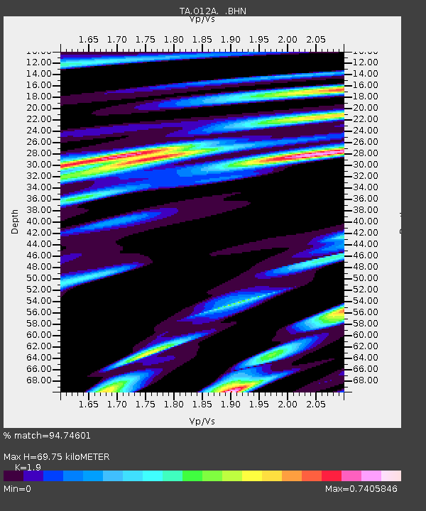
| Estimated Moho Depth: |
69.75 km |
| Estimated Crust Vp/Vs: |
1.90 |
| Assumed Crust Vp: |
6.276 km/s |
| Estimated Crust Vs: |
3.303 km/s |
| Estimated Crust Poisson's Ratio: |
0.31 |
|
| Radial Match: |
94.74601 % |
| Radial Bump: |
400 |
| Transverse Match: |
89.329994 % |
| Transverse Bump: |
400 |
| SOD ConfigId: |
2564 |
| Insert Time: |
2010-03-05 23:02:28.853 +0000 |
| GWidth: |
2.5 |
| Max Bumps: |
400 |
| Tol: |
0.001 |
|
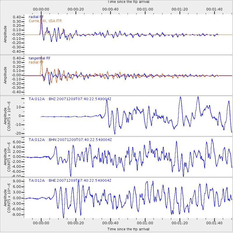
Signal To Noise
| Channel | StoN | STA | LTA |
| TA:O12A: :BHN:20071209T07:40:22.549004Z | 1.4791253 | 2.3591123E-7 | 1.5949374E-7 |
| TA:O12A: :BHE:20071209T07:40:22.549004Z | 1.300745 | 3.6335376E-7 | 2.793428E-7 |
| TA:O12A: :BHZ:20071209T07:40:22.549004Z | 6.160477 | 1.0848627E-6 | 1.7610043E-7 |
| Arrivals |
| Ps | 10 SECOND |
| PpPs | 32 SECOND |
| PsPs/PpSs | 42 SECOND |


