You are here: Home > Network List > ZP16 - Seismic Investigation of South Central Oklahoma Stations List
> Station SC09 Katie, Oklahoma, USA > Earthquake Result Viewer
SC09 Katie, Oklahoma, USA - Earthquake Result Viewer
| Earthquake location: |
Chile-Argentina Border Region |
| Earthquake latitude/longitude: |
-23.2/-67.7 |
| Earthquake time(UTC): |
2017/04/15 (105) 08:19:41 GMT |
| Earthquake Depth: |
135 km |
| Earthquake Magnitude: |
6.2 Mww |
| Earthquake Catalog/Contributor: |
NEIC PDE/us |
|
| Network: |
ZP Seismic Investigation of South Central Oklahoma |
| Station: |
SC09 Katie, Oklahoma, USA |
| Lat/Lon: |
34.55 N/97.37 W |
| Elevation: |
291 m |
|
| Distance: |
64.0 deg |
| Az: |
332.927 deg |
| Baz: |
149.525 deg |
| Ray Param: |
0.05881148 |
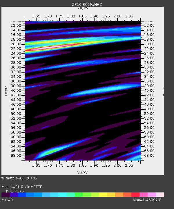
| Estimated Moho Depth: |
21.0 km |
| Estimated Crust Vp/Vs: |
1.72 |
| Assumed Crust Vp: |
6.426 km/s |
| Estimated Crust Vs: |
3.742 km/s |
| Estimated Crust Poisson's Ratio: |
0.24 |
|
| Radial Match: |
80.28402 % |
| Radial Bump: |
400 |
| Transverse Match: |
84.14278 % |
| Transverse Bump: |
400 |
| SOD ConfigId: |
11737051 |
| Insert Time: |
2019-04-27 02:59:15.434 +0000 |
| GWidth: |
2.5 |
| Max Bumps: |
400 |
| Tol: |
0.001 |
|

Signal To Noise
| Channel | StoN | STA | LTA |
| ZP:SC09: :HHZ:20170415T08:29:29.553013Z | 21.766527 | 2.3205298E-6 | 1.0661002E-7 |
| ZP:SC09: :HH1:20170415T08:29:29.553013Z | 12.0810585 | 1.3702614E-6 | 1.134223E-7 |
| ZP:SC09: :HH2:20170415T08:29:29.553013Z | 10.194833 | 9.549059E-7 | 9.366567E-8 |
| Arrivals |
| Ps | 2.4 SECOND |
| PpPs | 8.5 SECOND |
| PsPs/PpSs | 11 SECOND |


