You are here: Home > Network List > TA - USArray Transportable Network (new EarthScope stations) Stations List
> Station O12A Currie, NV, USA > Earthquake Result Viewer
O12A Currie, NV, USA - Earthquake Result Viewer
| Earthquake location: |
East Of Kuril Islands |
| Earthquake latitude/longitude: |
46.0/154.2 |
| Earthquake time(UTC): |
2007/10/25 (298) 13:50:02 GMT |
| Earthquake Depth: |
10 km |
| Earthquake Magnitude: |
6.0 MB, 5.7 MS, 6.1 MW, 5.9 MW |
| Earthquake Catalog/Contributor: |
WHDF/NEIC |
|
| Network: |
TA USArray Transportable Network (new EarthScope stations) |
| Station: |
O12A Currie, NV, USA |
| Lat/Lon: |
40.27 N/114.75 W |
| Elevation: |
1743 m |
|
| Distance: |
63.1 deg |
| Az: |
59.063 deg |
| Baz: |
308.624 deg |
| Ray Param: |
0.0597842 |
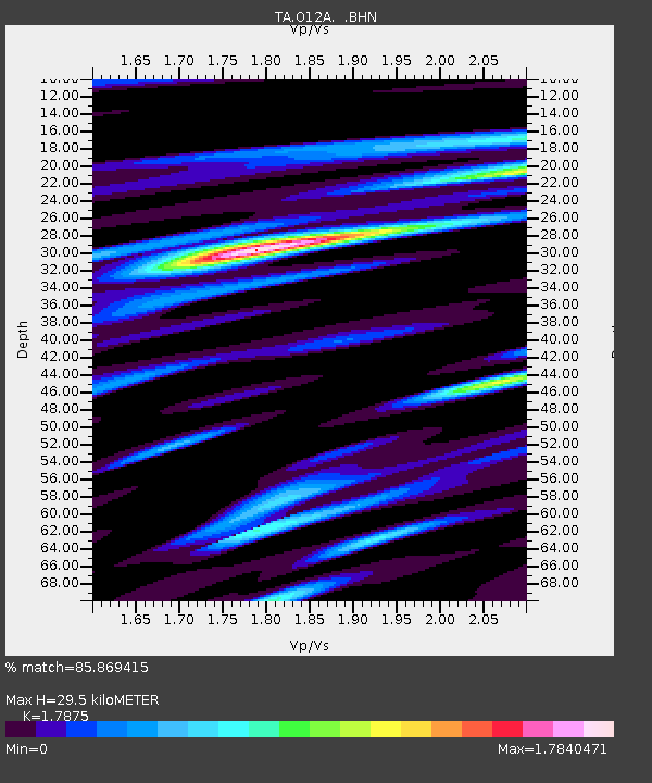
| Estimated Moho Depth: |
29.5 km |
| Estimated Crust Vp/Vs: |
1.79 |
| Assumed Crust Vp: |
6.276 km/s |
| Estimated Crust Vs: |
3.511 km/s |
| Estimated Crust Poisson's Ratio: |
0.27 |
|
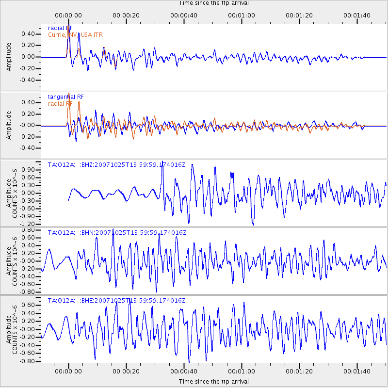
| Radial Match: |
85.869415 % |
| Radial Bump: |
400 |
| Transverse Match: |
76.83539 % |
| Transverse Bump: |
400 |
| SOD ConfigId: |
2564 |
| Insert Time: |
2010-03-05 23:02:39.578 +0000 |
| GWidth: |
2.5 |
| Max Bumps: |
400 |
| Tol: |
0.001 |
|
Signal To Noise
| Channel | StoN | STA | LTA |
| TA:O12A: :BHN:20071025T13:59:59.174016Z | 2.0500808 | 1.9643642E-7 | 9.581887E-8 |
| TA:O12A: :BHE:20071025T13:59:59.174016Z | 1.9361082 | 2.3225965E-7 | 1.1996212E-7 |
| TA:O12A: :BHZ:20071025T13:59:59.174016Z | 3.1588173 | 4.0762507E-7 | 1.2904357E-7 |
| Arrivals |
| Ps | 3.9 SECOND |
| PpPs | 13 SECOND |
| PsPs/PpSs | 16 SECOND |


