You are here: Home > Network List > KZ - Kazakhstan Network Stations List
> Station ABKAR Akbulak array,AB31, Kazakhstan > Earthquake Result Viewer
ABKAR Akbulak array,AB31, Kazakhstan - Earthquake Result Viewer
| Earthquake location: |
South Indian Ocean |
| Earthquake latitude/longitude: |
-7.3/83.2 |
| Earthquake time(UTC): |
2017/04/16 (106) 09:44:06 GMT |
| Earthquake Depth: |
10 km |
| Earthquake Magnitude: |
5.7 mb |
| Earthquake Catalog/Contributor: |
NEIC PDE/us |
|
| Network: |
KZ Kazakhstan Network |
| Station: |
ABKAR Akbulak array,AB31, Kazakhstan |
| Lat/Lon: |
49.26 N/59.94 E |
| Elevation: |
362 m |
|
| Distance: |
59.9 deg |
| Az: |
342.619 deg |
| Baz: |
153.112 deg |
| Ray Param: |
0.06187633 |
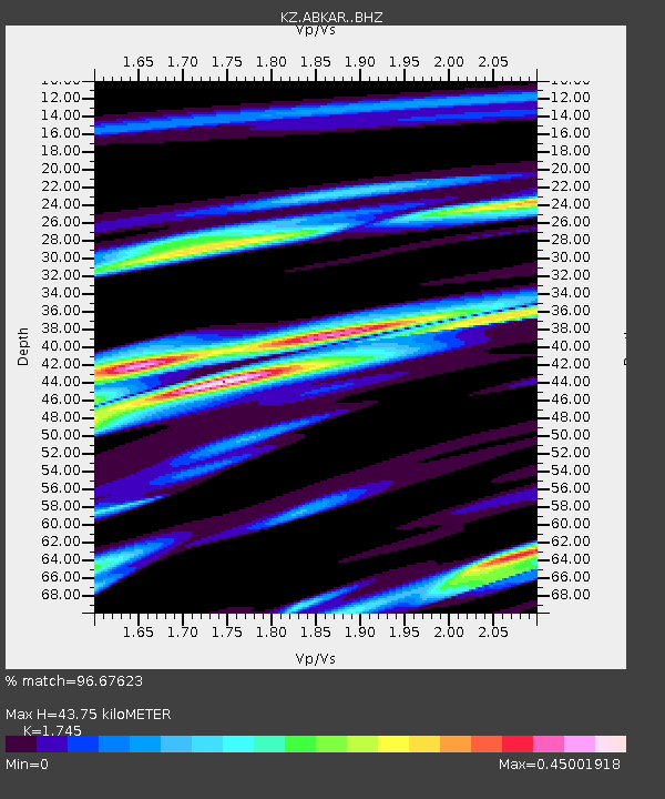
| Estimated Moho Depth: |
43.75 km |
| Estimated Crust Vp/Vs: |
1.75 |
| Assumed Crust Vp: |
6.35 km/s |
| Estimated Crust Vs: |
3.639 km/s |
| Estimated Crust Poisson's Ratio: |
0.26 |
|
| Radial Match: |
96.67623 % |
| Radial Bump: |
273 |
| Transverse Match: |
88.46709 % |
| Transverse Bump: |
400 |
| SOD ConfigId: |
11737051 |
| Insert Time: |
2019-04-27 03:02:03.195 +0000 |
| GWidth: |
2.5 |
| Max Bumps: |
400 |
| Tol: |
0.001 |
|

Signal To Noise
| Channel | StoN | STA | LTA |
| KZ:ABKAR: :BHZ:20170416T09:53:40.875979Z | 21.08796 | 1.416734E-6 | 6.718213E-8 |
| KZ:ABKAR: :BHN:20170416T09:53:40.875979Z | 16.48792 | 6.6547085E-7 | 4.0361112E-8 |
| KZ:ABKAR: :BHE:20170416T09:53:40.875979Z | 11.344654 | 3.9538102E-7 | 3.4851748E-8 |
| Arrivals |
| Ps | 5.4 SECOND |
| PpPs | 18 SECOND |
| PsPs/PpSs | 23 SECOND |


