You are here: Home > Network List > TA - USArray Transportable Network (new EarthScope stations) Stations List
> Station O12A Currie, NV, USA > Earthquake Result Viewer
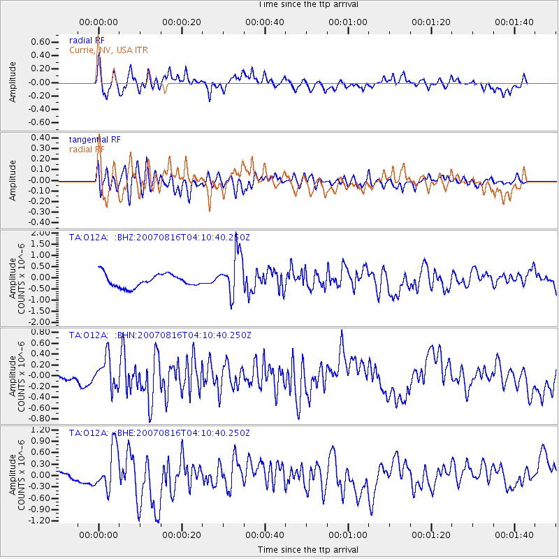
O12A Currie, NV, USA - Earthquake Result Viewer
| Earthquake location: |
Andreanof Islands, Aleutian Is. |
| Earthquake latitude/longitude: |
50.2/-177.6 |
| Earthquake time(UTC): |
2007/08/16 (228) 04:03:03 GMT |
| Earthquake Depth: |
15 km |
| Earthquake Magnitude: |
5.8 MB |
| Earthquake Catalog/Contributor: |
WHDF/NEIC |
|
| Network: |
TA USArray Transportable Network (new EarthScope stations) |
| Station: |
O12A Currie, NV, USA |
| Lat/Lon: |
40.27 N/114.75 W |
| Elevation: |
1743 m |
|
| Distance: |
44.1 deg |
| Az: |
77.938 deg |
| Baz: |
304.855 deg |
| Ray Param: |
0.07210577 |
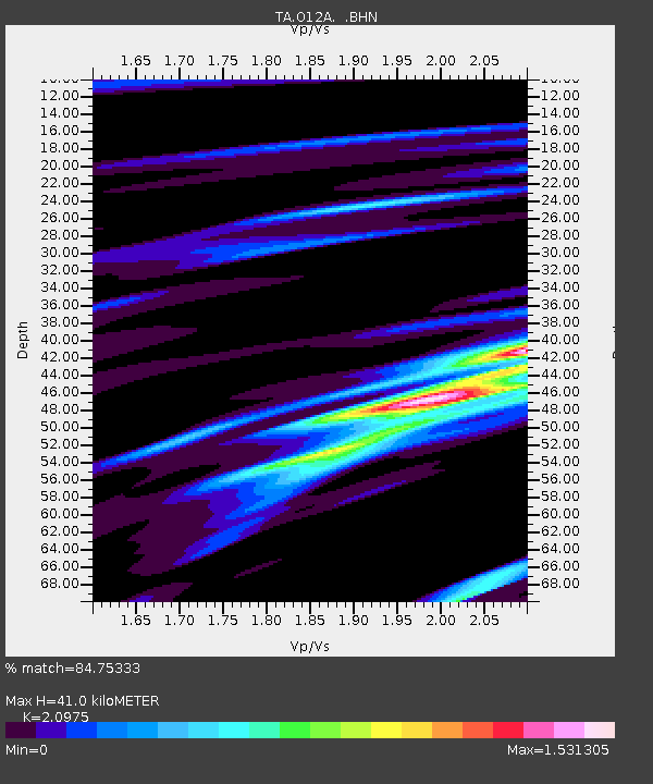
| Estimated Moho Depth: |
41.0 km |
| Estimated Crust Vp/Vs: |
2.10 |
| Assumed Crust Vp: |
6.276 km/s |
| Estimated Crust Vs: |
2.992 km/s |
| Estimated Crust Poisson's Ratio: |
0.35 |
|
| Radial Match: |
84.75333 % |
| Radial Bump: |
400 |
| Transverse Match: |
59.472 % |
| Transverse Bump: |
400 |
| SOD ConfigId: |
2564 |
| Insert Time: |
2010-03-05 23:02:53.609 +0000 |
| GWidth: |
2.5 |
| Max Bumps: |
400 |
| Tol: |
0.001 |
|
Signal To Noise
| Channel | StoN | STA | LTA |
| TA:O12A: :BHN:20070816T04:10:40.250Z | 2.994767 | 2.8147832E-7 | 9.399005E-8 |
| TA:O12A: :BHE:20070816T04:10:40.250Z | 3.5064726 | 5.644811E-7 | 1.6098262E-7 |
| TA:O12A: :BHZ:20070816T04:10:40.250Z | 3.4796147 | 9.894367E-7 | 2.8435238E-7 |
| Arrivals |
| Ps | 7.6 SECOND |
| PpPs | 19 SECOND |
| PsPs/PpSs | 27 SECOND |


