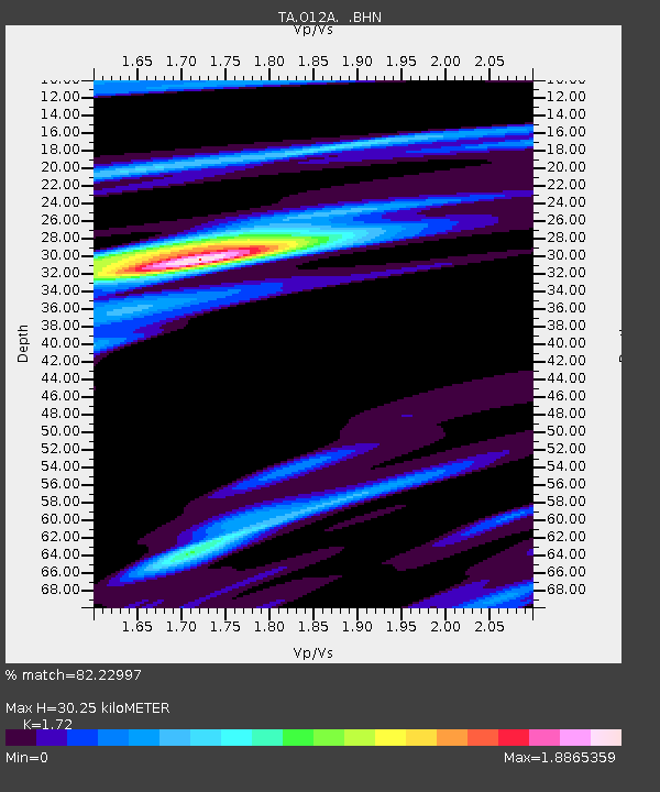
O12A Currie, NV, USA - Earthquake Result Viewer
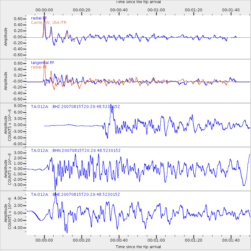
Earthquake location: Andreanof Islands, Aleutian Is.
Earthquake latitude/longitude: 50.3/-177.5
Earthquake time(UTC): 2007/08/15 (227) 20:22:11 GMT
Earthquake Depth: 9.0 km
Earthquake Magnitude: 6.3 MB, 6.2 MS, 6.4 MW, 5.9 ML
Earthquake Catalog/Contributor: WHDF/NEIC
Network: TA USArray Transportable Network (new EarthScope stations)
Station: O12A Currie, NV, USA
Lat/Lon: 40.27 N/114.75 W
Elevation: 1743 m
Distance: 44.1 deg
Az: 78.031 deg
Baz: 304.963 deg
Ray Param: 0.07213796
Estimated Moho Depth: 30.25 km
Estimated Crust Vp/Vs: 1.72
Assumed Crust Vp: 6.276 km/s
Estimated Crust Vs: 3.649 km/s
Estimated Crust Poisson's Ratio: 0.24
Radial Match: 82.22997 %
Radial Bump: 400
Transverse Match: 73.41617 %
Transverse Bump: 400
SOD ConfigId: 2564
Insert Time: 2010-03-05 23:02:57.868 +0000
GWidth: 2.5
Max Bumps: 400
Tol: 0.001

Signal To Noise

ChannelStoNSTALTA
TA:O12A: :BHN:20070815T20:29:48.523015Z6.1377929.0461367E-71.4738423E-7
TA:O12A: :BHE:20070815T20:29:48.523015Z3.01998781.1234016E-63.719888E-7
TA:O12A: :BHZ:20070815T20:29:48.523015Z10.920772.2223212E-62.0349493E-7
Arrivals
Ps3.7 SECOND
PpPs12 SECOND
PsPs/PpSs16 SECOND