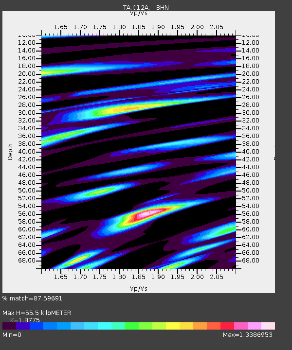
O12A Currie, NV, USA - Earthquake Result Viewer

Earthquake location: Near West Coast Of Honshu, Japan
Earthquake latitude/longitude: 37.5/138.5
Earthquake time(UTC): 2007/07/16 (197) 06:37:40 GMT
Earthquake Depth: 15 km
Earthquake Magnitude: 5.7 MB, 5.1 MS, 5.7 MW, 5.6 MW
Earthquake Catalog/Contributor: WHDF/NEIC
Network: TA USArray Transportable Network (new EarthScope stations)
Station: O12A Currie, NV, USA
Lat/Lon: 40.27 N/114.75 W
Elevation: 1743 m
Distance: 77.6 deg
Az: 48.592 deg
Baz: 308.78 deg
Ray Param: 0.050194968
Estimated Moho Depth: 55.5 km
Estimated Crust Vp/Vs: 1.88
Assumed Crust Vp: 6.276 km/s
Estimated Crust Vs: 3.343 km/s
Estimated Crust Poisson's Ratio: 0.30
Radial Match: 87.59691 %
Radial Bump: 400
Transverse Match: 78.00272 %
Transverse Bump: 400
SOD ConfigId: 2564
Insert Time: 2010-03-05 23:03:01.229 +0000
GWidth: 2.5
Max Bumps: 400
Tol: 0.001

Signal To Noise

ChannelStoNSTALTA
TA:O12A: :BHN:20070716T06:49:04.523018Z2.43529961.2858531E-75.280061E-8
TA:O12A: :BHE:20070716T06:49:04.523018Z4.56757741.7939759E-73.9276312E-8
TA:O12A: :BHZ:20070716T06:49:04.523018Z16.8745445.3511195E-73.1711192E-8
Arrivals
Ps8.0 SECOND
PpPs25 SECOND
PsPs/PpSs33 SECOND