You are here: Home > Network List > GS - US Geological Survey Networks Stations List
> Station KAN12 Houston Home, Harper, KS, USA > Earthquake Result Viewer
KAN12 Houston Home, Harper, KS, USA - Earthquake Result Viewer
| Earthquake location: |
Peru-Brazil Border Region |
| Earthquake latitude/longitude: |
-10.6/-71.0 |
| Earthquake time(UTC): |
2015/11/24 (328) 22:45:38 GMT |
| Earthquake Depth: |
602 km |
| Earthquake Magnitude: |
7.5 MWW, 6.9 MI |
| Earthquake Catalog/Contributor: |
NEIC PDE/NEIC COMCAT |
|
| Network: |
GS US Geological Survey Networks |
| Station: |
KAN12 Houston Home, Harper, KS, USA |
| Lat/Lon: |
37.30 N/98.00 W |
| Elevation: |
426 m |
|
| Distance: |
54.0 deg |
| Az: |
333.372 deg |
| Baz: |
146.454 deg |
| Ray Param: |
0.06309984 |
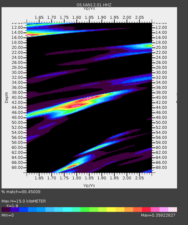
| Estimated Moho Depth: |
15.0 km |
| Estimated Crust Vp/Vs: |
1.60 |
| Assumed Crust Vp: |
6.483 km/s |
| Estimated Crust Vs: |
4.052 km/s |
| Estimated Crust Poisson's Ratio: |
0.18 |
|
| Radial Match: |
88.45008 % |
| Radial Bump: |
396 |
| Transverse Match: |
80.36662 % |
| Transverse Bump: |
400 |
| SOD ConfigId: |
1259291 |
| Insert Time: |
2015-12-08 23:35:22.869 +0000 |
| GWidth: |
2.5 |
| Max Bumps: |
400 |
| Tol: |
0.001 |
|

Signal To Noise
| Channel | StoN | STA | LTA |
| GS:KAN12:01:HHZ:20151124T22:53:36.304995Z | 44.16714 | 1.9517689E-5 | 4.419052E-7 |
| GS:KAN12:01:HHN:20151124T22:53:36.304995Z | 7.084391 | 7.1153013E-6 | 1.0043631E-6 |
| GS:KAN12:01:HHE:20151124T22:53:36.304995Z | 3.0029438 | 4.8358893E-6 | 1.6103829E-6 |
| Arrivals |
| Ps | 1.5 SECOND |
| PpPs | 5.7 SECOND |
| PsPs/PpSs | 7.2 SECOND |


