You are here: Home > Network List > TA - USArray Transportable Network (new EarthScope stations) Stations List
> Station O12A Currie, NV, USA > Earthquake Result Viewer
O12A Currie, NV, USA - Earthquake Result Viewer
| Earthquake location: |
Tonga Islands |
| Earthquake latitude/longitude: |
-20.1/-174.5 |
| Earthquake time(UTC): |
2007/05/27 (147) 18:12:34 GMT |
| Earthquake Depth: |
7.3 km |
| Earthquake Magnitude: |
5.8 MB, 5.1 MS, 5.6 MW, 5.5 MW |
| Earthquake Catalog/Contributor: |
WHDF/NEIC |
|
| Network: |
TA USArray Transportable Network (new EarthScope stations) |
| Station: |
O12A Currie, NV, USA |
| Lat/Lon: |
40.27 N/114.75 W |
| Elevation: |
1743 m |
|
| Distance: |
81.8 deg |
| Az: |
41.909 deg |
| Baz: |
235.144 deg |
| Ray Param: |
0.04733058 |
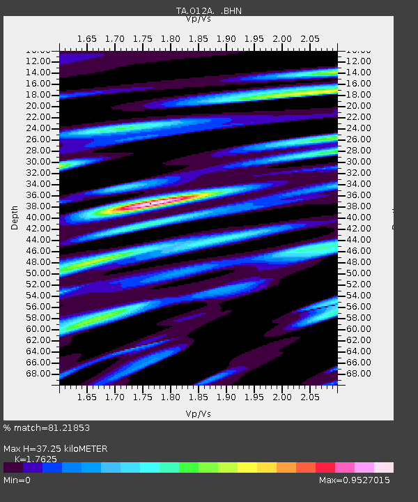
| Estimated Moho Depth: |
37.25 km |
| Estimated Crust Vp/Vs: |
1.76 |
| Assumed Crust Vp: |
6.276 km/s |
| Estimated Crust Vs: |
3.561 km/s |
| Estimated Crust Poisson's Ratio: |
0.26 |
|
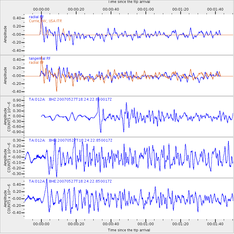
| Radial Match: |
81.21853 % |
| Radial Bump: |
400 |
| Transverse Match: |
69.796394 % |
| Transverse Bump: |
400 |
| SOD ConfigId: |
2564 |
| Insert Time: |
2010-03-05 23:03:17.076 +0000 |
| GWidth: |
2.5 |
| Max Bumps: |
400 |
| Tol: |
0.001 |
|
Signal To Noise
| Channel | StoN | STA | LTA |
| TA:O12A: :BHN:20070527T18:24:22.850017Z | 1.797344 | 1.0687383E-7 | 5.946209E-8 |
| TA:O12A: :BHE:20070527T18:24:22.850017Z | 4.388198 | 2.4629898E-7 | 5.6127593E-8 |
| TA:O12A: :BHZ:20070527T18:24:22.850017Z | 4.3766603 | 4.3658648E-7 | 9.975334E-8 |
| Arrivals |
| Ps | 4.6 SECOND |
| PpPs | 16 SECOND |
| PsPs/PpSs | 21 SECOND |


