You are here: Home > Network List > TA - USArray Transportable Network (new EarthScope stations) Stations List
> Station O12A Currie, NV, USA > Earthquake Result Viewer
O12A Currie, NV, USA - Earthquake Result Viewer
| Earthquake location: |
Trinidad |
| Earthquake latitude/longitude: |
10.9/-61.8 |
| Earthquake time(UTC): |
2006/09/29 (272) 13:08:26 GMT |
| Earthquake Depth: |
53 km |
| Earthquake Magnitude: |
5.9 MB, 5.4 MS, 6.1 MW, 6.0 MW |
| Earthquake Catalog/Contributor: |
WHDF/NEIC |
|
| Network: |
TA USArray Transportable Network (new EarthScope stations) |
| Station: |
O12A Currie, NV, USA |
| Lat/Lon: |
40.27 N/114.75 W |
| Elevation: |
1743 m |
|
| Distance: |
55.0 deg |
| Az: |
311.788 deg |
| Baz: |
106.829 deg |
| Ray Param: |
0.064928636 |
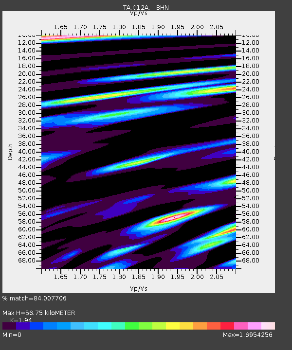
| Estimated Moho Depth: |
56.75 km |
| Estimated Crust Vp/Vs: |
1.94 |
| Assumed Crust Vp: |
6.276 km/s |
| Estimated Crust Vs: |
3.235 km/s |
| Estimated Crust Poisson's Ratio: |
0.32 |
|
| Radial Match: |
84.007706 % |
| Radial Bump: |
400 |
| Transverse Match: |
76.08344 % |
| Transverse Bump: |
400 |
| SOD ConfigId: |
2564 |
| Insert Time: |
2010-03-05 23:03:24.442 +0000 |
| GWidth: |
2.5 |
| Max Bumps: |
400 |
| Tol: |
0.001 |
|

Signal To Noise
| Channel | StoN | STA | LTA |
| TA:O12A: :BHN:20060929T13:17:21.724016Z | 1.828575 | 1.6331235E-7 | 8.9311264E-8 |
| TA:O12A: :BHE:20060929T13:17:21.724016Z | 2.3405547 | 2.7683228E-7 | 1.1827636E-7 |
| TA:O12A: :BHZ:20060929T13:17:21.724016Z | 12.932212 | 8.069913E-7 | 6.240164E-8 |
| Arrivals |
| Ps | 8.9 SECOND |
| PpPs | 25 SECOND |
| PsPs/PpSs | 34 SECOND |


