You are here: Home > Network List > TA - USArray Transportable Network (new EarthScope stations) Stations List
> Station O12A Currie, NV, USA > Earthquake Result Viewer
O12A Currie, NV, USA - Earthquake Result Viewer
| Earthquake location: |
Near East Coast Of Kamchatka |
| Earthquake latitude/longitude: |
55.6/161.7 |
| Earthquake time(UTC): |
2006/08/17 (229) 11:11:35 GMT |
| Earthquake Depth: |
55 km |
| Earthquake Magnitude: |
6.1 MB, 5.7 MW, 5.7 MW |
| Earthquake Catalog/Contributor: |
WHDF/NEIC |
|
| Network: |
TA USArray Transportable Network (new EarthScope stations) |
| Station: |
O12A Currie, NV, USA |
| Lat/Lon: |
40.27 N/114.75 W |
| Elevation: |
1743 m |
|
| Distance: |
54.6 deg |
| Az: |
68.817 deg |
| Baz: |
316.266 deg |
| Ray Param: |
0.065187424 |
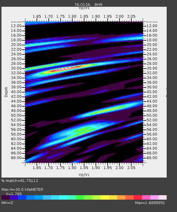
| Estimated Moho Depth: |
30.0 km |
| Estimated Crust Vp/Vs: |
1.76 |
| Assumed Crust Vp: |
6.276 km/s |
| Estimated Crust Vs: |
3.556 km/s |
| Estimated Crust Poisson's Ratio: |
0.26 |
|
| Radial Match: |
91.75112 % |
| Radial Bump: |
400 |
| Transverse Match: |
85.861015 % |
| Transverse Bump: |
400 |
| SOD ConfigId: |
2564 |
| Insert Time: |
2010-03-05 23:03:26.577 +0000 |
| GWidth: |
2.5 |
| Max Bumps: |
400 |
| Tol: |
0.001 |
|
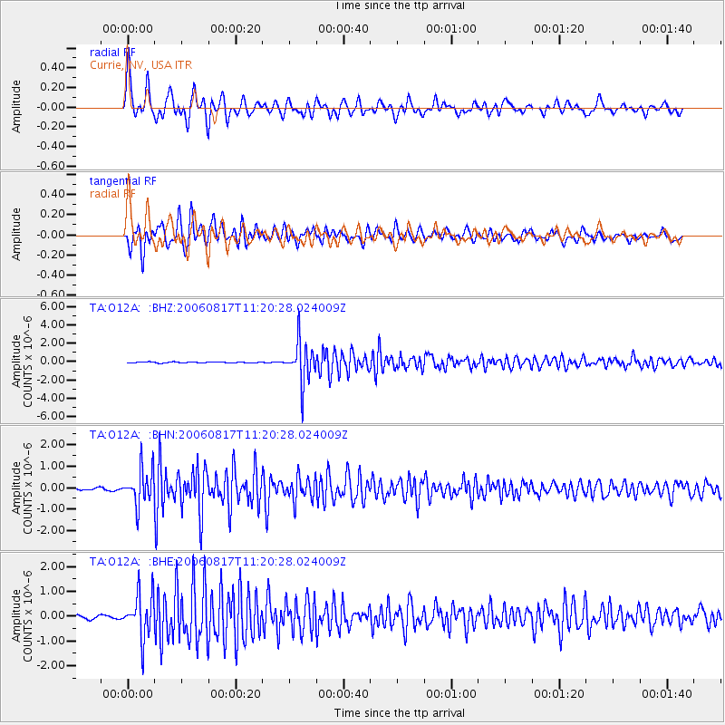
Signal To Noise
| Channel | StoN | STA | LTA |
| TA:O12A: :BHN:20060817T11:20:28.024009Z | 10.623991 | 8.352136E-7 | 7.8615805E-8 |
| TA:O12A: :BHE:20060817T11:20:28.024009Z | 9.790924 | 8.879213E-7 | 9.06882E-8 |
| TA:O12A: :BHZ:20060817T11:20:28.024009Z | 43.30735 | 2.2461008E-6 | 5.1864195E-8 |
| Arrivals |
| Ps | 3.8 SECOND |
| PpPs | 13 SECOND |
| PsPs/PpSs | 16 SECOND |


