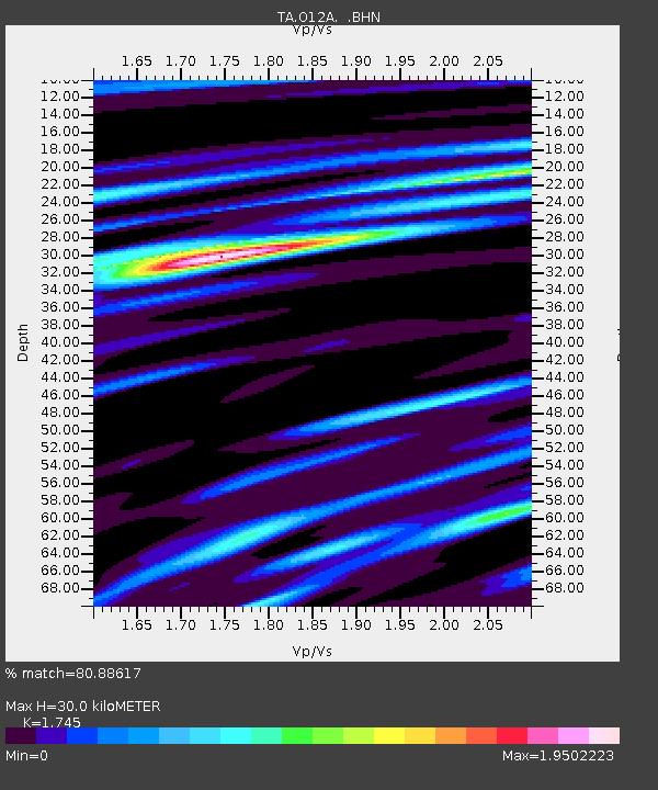
O12A Currie, NV, USA - Earthquake Result Viewer
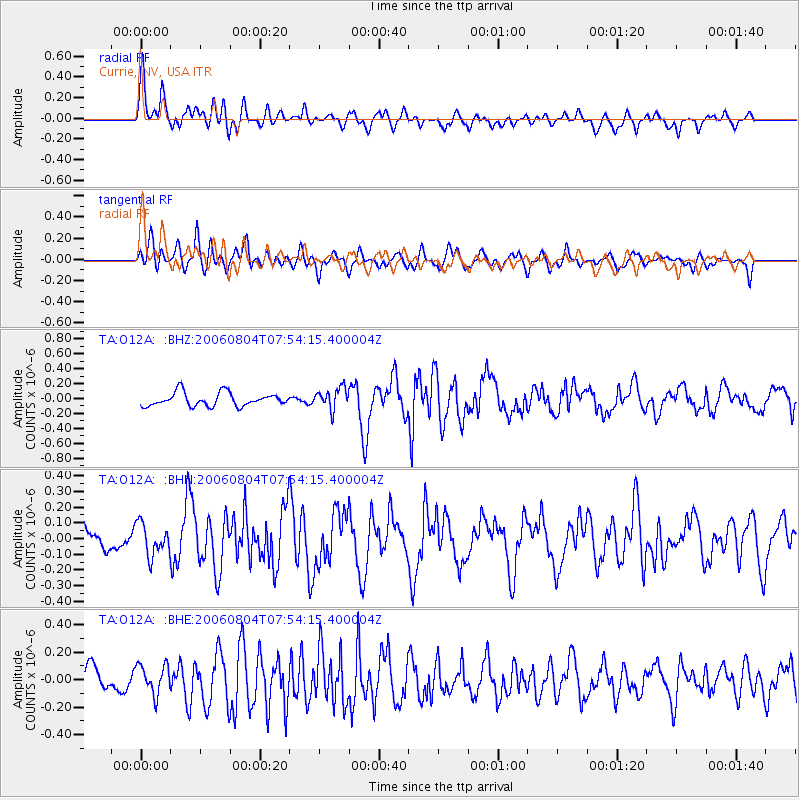
Earthquake location: Near Islands, Aleutian Islands
Earthquake latitude/longitude: 52.1/171.0
Earthquake time(UTC): 2006/08/04 (216) 07:45:47 GMT
Earthquake Depth: 10 km
Earthquake Magnitude: 5.4 MB, 4.9 MS, 5.5 MW, 5.5 MW
Earthquake Catalog/Contributor: WHDF/NEIC
Network: TA USArray Transportable Network (new EarthScope stations)
Station: O12A Currie, NV, USA
Lat/Lon: 40.27 N/114.75 W
Elevation: 1743 m
Distance: 50.6 deg
Az: 72.431 deg
Baz: 309.807 deg
Ray Param: 0.067971215
Estimated Moho Depth: 30.0 km
Estimated Crust Vp/Vs: 1.75
Assumed Crust Vp: 6.276 km/s
Estimated Crust Vs: 3.596 km/s
Estimated Crust Poisson's Ratio: 0.26
Radial Match: 80.88617 %
Radial Bump: 400
Transverse Match: 67.52402 %
Transverse Bump: 400
SOD ConfigId: 5423
Insert Time: 2010-03-05 23:03:37.745 +0000
GWidth: 2.5
Max Bumps: 400
Tol: 0.001

Signal To Noise

ChannelStoNSTALTA
TA:O12A: :BHN:20060804T07:54:15.400004Z1.05430471.0064693E-79.5462845E-8
TA:O12A: :BHE:20060804T07:54:15.400004Z1.15861741.0873009E-79.38447E-8
TA:O12A: :BHZ:20060804T07:54:15.400004Z1.58141781.4194993E-78.976117E-8
Arrivals
Ps3.8 SECOND
PpPs12 SECOND
PsPs/PpSs16 SECOND