You are here: Home > Network List > CN - Canadian National Seismograph Network Stations List
> Station INK INUVIK, NT > Earthquake Result Viewer
INK INUVIK, NT - Earthquake Result Viewer
*The percent match for this event was below the threshold and hence no stack was calculated.
| Earthquake location: |
Vanuatu Islands |
| Earthquake latitude/longitude: |
-13.4/166.5 |
| Earthquake time(UTC): |
2017/04/17 (107) 02:21:32 GMT |
| Earthquake Depth: |
20 km |
| Earthquake Magnitude: |
5.7 Mww |
| Earthquake Catalog/Contributor: |
NEIC PDE/us |
|
| Network: |
CN Canadian National Seismograph Network |
| Station: |
INK INUVIK, NT |
| Lat/Lon: |
68.31 N/133.53 W |
| Elevation: |
44 m |
|
| Distance: |
91.9 deg |
| Az: |
18.78 deg |
| Baz: |
237.427 deg |
| Ray Param: |
$rayparam |
*The percent match for this event was below the threshold and hence was not used in the summary stack. |
|
| Radial Match: |
31.315077 % |
| Radial Bump: |
400 |
| Transverse Match: |
48.217995 % |
| Transverse Bump: |
400 |
| SOD ConfigId: |
11737051 |
| Insert Time: |
2019-04-27 03:06:22.343 +0000 |
| GWidth: |
2.5 |
| Max Bumps: |
400 |
| Tol: |
0.001 |
|
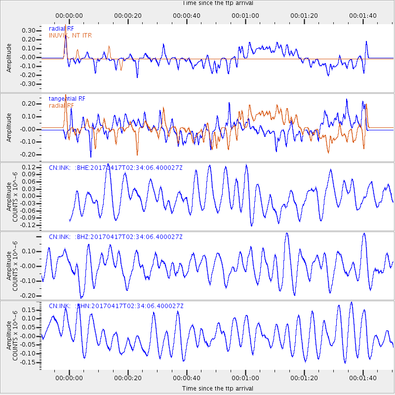
Signal To Noise
| Channel | StoN | STA | LTA |
| CN:INK: :BHZ:20170417T02:34:06.400027Z | 1.1440893 | 1.01794896E-7 | 8.897461E-8 |
| CN:INK: :BHN:20170417T02:34:06.400027Z | 1.1746566 | 1.1068745E-7 | 9.422963E-8 |
| CN:INK: :BHE:20170417T02:34:06.400027Z | 0.64134425 | 3.5895614E-8 | 5.5969345E-8 |
| Arrivals |
| Ps | |
| PpPs | |
| PsPs/PpSs | |


