You are here: Home > Network List > II - Global Seismograph Network (GSN - IRIS/IDA) Stations List
> Station EFI Mount Kent, East Falkland Island > Earthquake Result Viewer
EFI Mount Kent, East Falkland Island - Earthquake Result Viewer
| Earthquake location: |
Peru-Brazil Border Region |
| Earthquake latitude/longitude: |
-10.6/-71.0 |
| Earthquake time(UTC): |
2015/11/24 (328) 22:45:38 GMT |
| Earthquake Depth: |
602 km |
| Earthquake Magnitude: |
7.5 MWW, 6.9 MI |
| Earthquake Catalog/Contributor: |
NEIC PDE/NEIC COMCAT |
|
| Network: |
II Global Seismograph Network (GSN - IRIS/IDA) |
| Station: |
EFI Mount Kent, East Falkland Island |
| Lat/Lon: |
51.68 S/58.06 W |
| Elevation: |
110 m |
|
| Distance: |
42.3 deg |
| Az: |
168.079 deg |
| Baz: |
340.964 deg |
| Ray Param: |
0.07014942 |
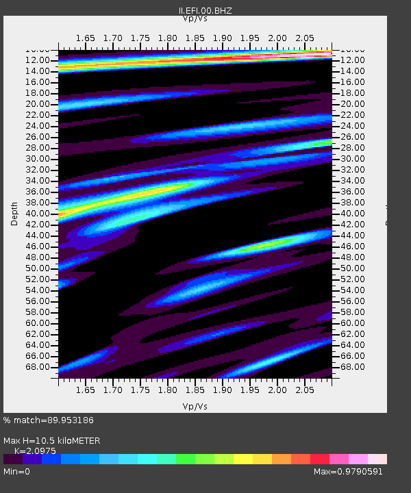
| Estimated Moho Depth: |
10.5 km |
| Estimated Crust Vp/Vs: |
2.10 |
| Assumed Crust Vp: |
6.472 km/s |
| Estimated Crust Vs: |
3.086 km/s |
| Estimated Crust Poisson's Ratio: |
0.35 |
|
| Radial Match: |
89.953186 % |
| Radial Bump: |
286 |
| Transverse Match: |
77.68424 % |
| Transverse Bump: |
386 |
| SOD ConfigId: |
1259291 |
| Insert Time: |
2015-12-08 23:36:28.309 +0000 |
| GWidth: |
2.5 |
| Max Bumps: |
400 |
| Tol: |
0.001 |
|

Signal To Noise
| Channel | StoN | STA | LTA |
| II:EFI:00:BHZ:20151124T22:52:10.169009Z | 16.824049 | 2.2833363E-5 | 1.357186E-6 |
| II:EFI:00:BH1:20151124T22:52:10.169009Z | 15.150452 | 1.1101109E-5 | 7.3272463E-7 |
| II:EFI:00:BH2:20151124T22:52:10.169009Z | 5.558125 | 5.1882084E-6 | 9.334458E-7 |
| Arrivals |
| Ps | 1.9 SECOND |
| PpPs | 4.8 SECOND |
| PsPs/PpSs | 6.6 SECOND |


