You are here: Home > Network List > TA - USArray Transportable Network (new EarthScope stations) Stations List
> Station O12A Currie, NV, USA > Earthquake Result Viewer
O12A Currie, NV, USA - Earthquake Result Viewer
| Earthquake location: |
Sea Of Japan |
| Earthquake latitude/longitude: |
41.4/135.7 |
| Earthquake time(UTC): |
2006/09/16 (259) 02:22:50 GMT |
| Earthquake Depth: |
367 km |
| Earthquake Magnitude: |
5.4 MB, 5.9 MW, 5.9 MW |
| Earthquake Catalog/Contributor: |
WHDF/NEIC |
|
| Network: |
TA USArray Transportable Network (new EarthScope stations) |
| Station: |
O12A Currie, NV, USA |
| Lat/Lon: |
40.27 N/114.75 W |
| Elevation: |
1743 m |
|
| Distance: |
76.6 deg |
| Az: |
47.823 deg |
| Baz: |
313.196 deg |
| Ray Param: |
0.04981486 |
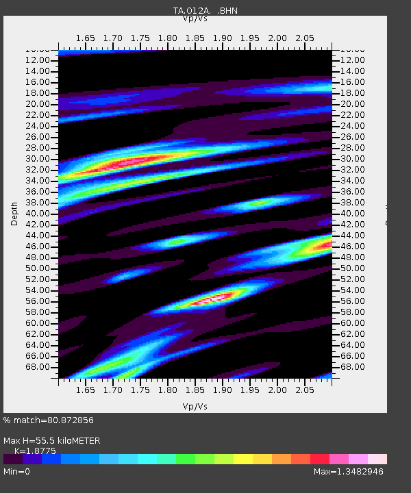
| Estimated Moho Depth: |
55.5 km |
| Estimated Crust Vp/Vs: |
1.88 |
| Assumed Crust Vp: |
6.276 km/s |
| Estimated Crust Vs: |
3.343 km/s |
| Estimated Crust Poisson's Ratio: |
0.30 |
|
| Radial Match: |
80.872856 % |
| Radial Bump: |
400 |
| Transverse Match: |
68.70711 % |
| Transverse Bump: |
394 |
| SOD ConfigId: |
2665 |
| Insert Time: |
2010-03-05 23:03:57.374 +0000 |
| GWidth: |
2.5 |
| Max Bumps: |
400 |
| Tol: |
0.001 |
|
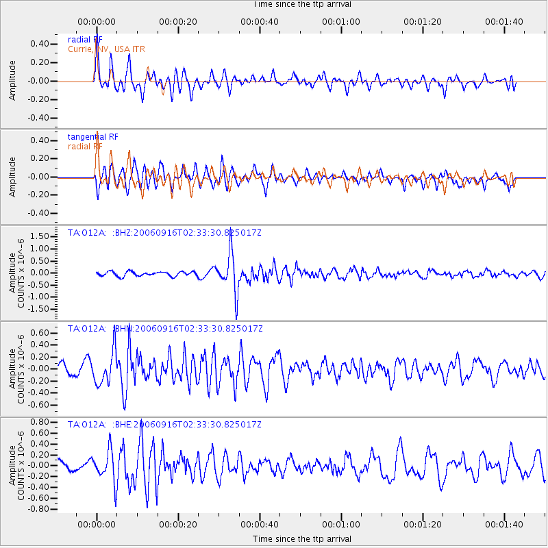
Signal To Noise
| Channel | StoN | STA | LTA |
| TA:O12A: :BHN:20060916T02:33:30.825017Z | 4.051434 | 2.8051812E-7 | 6.923921E-8 |
| TA:O12A: :BHE:20060916T02:33:30.825017Z | 2.7627156 | 2.9450277E-7 | 1.0659902E-7 |
| TA:O12A: :BHZ:20060916T02:33:30.825017Z | 8.998566 | 8.244994E-7 | 9.1625644E-8 |
| Arrivals |
| Ps | 8.0 SECOND |
| PpPs | 25 SECOND |
| PsPs/PpSs | 33 SECOND |


