You are here: Home > Network List > TA - USArray Transportable Network (new EarthScope stations) Stations List
> Station O12A Currie, NV, USA > Earthquake Result Viewer
O12A Currie, NV, USA - Earthquake Result Viewer

| Earthquake location: |
Near East Coast Of Kamchatka |
| Earthquake latitude/longitude: |
51.1/157.5 |
| Earthquake time(UTC): |
2006/08/24 (236) 21:50:36 GMT |
| Earthquake Depth: |
43 km |
| Earthquake Magnitude: |
5.9 MB, 6.2 MS, 6.5 MW, 6.5 MW |
| Earthquake Catalog/Contributor: |
WHDF/NEIC |
|
| Network: |
TA USArray Transportable Network (new EarthScope stations) |
| Station: |
O12A Currie, NV, USA |
| Lat/Lon: |
40.27 N/114.75 W |
| Elevation: |
1743 m |
|
| Distance: |
58.7 deg |
| Az: |
63.451 deg |
| Baz: |
312.577 deg |
| Ray Param: |
0.06256671 |
| Estimated Moho Depth: |
30.0 km |
| Estimated Crust Vp/Vs: |
1.75 |
| Assumed Crust Vp: |
6.276 km/s |
| Estimated Crust Vs: |
3.576 km/s |
| Estimated Crust Poisson's Ratio: |
0.26 |
|
| Radial Match: |
90.658356 % |
| Radial Bump: |
400 |
| Transverse Match: |
86.03864 % |
| Transverse Bump: |
400 |
| SOD ConfigId: |
2665 |
| Insert Time: |
2010-03-05 23:04:00.316 +0000 |
| GWidth: |
2.5 |
| Max Bumps: |
400 |
| Tol: |
0.001 |
|
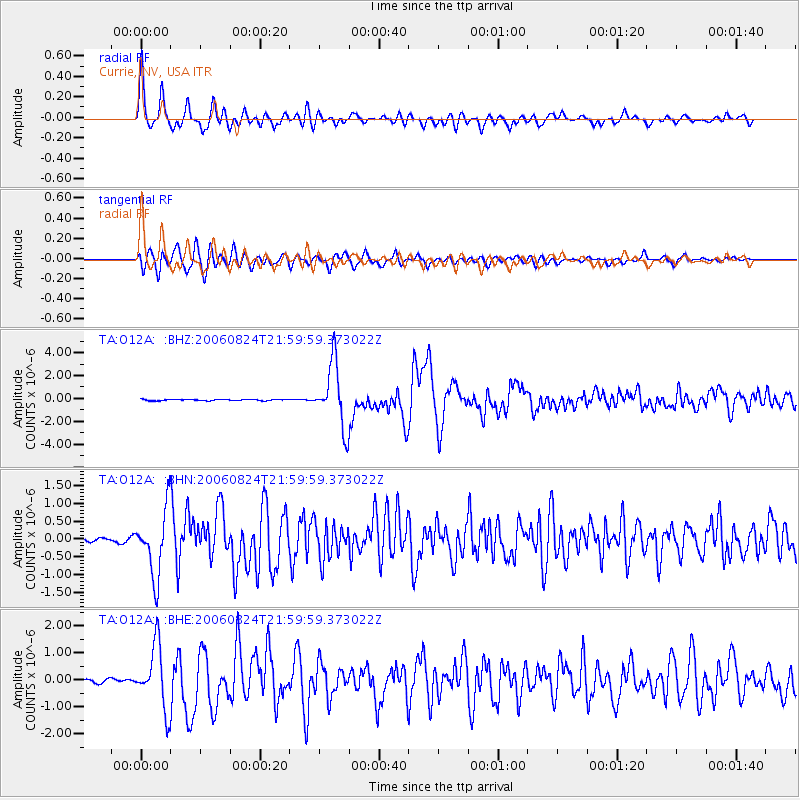
Signal To Noise
| Channel | StoN | STA | LTA |
| TA:O12A: :BHN:20060824T21:59:59.373022Z | 10.512115 | 9.1986254E-7 | 8.7505E-8 |
| TA:O12A: :BHE:20060824T21:59:59.373022Z | 18.919542 | 1.1511178E-6 | 6.0842794E-8 |
| TA:O12A: :BHZ:20060824T21:59:59.373022Z | 50.047653 | 2.7629499E-6 | 5.520638E-8 |
| Arrivals |
| Ps | 3.8 SECOND |
| PpPs | 13 SECOND |
| PsPs/PpSs | 16 SECOND |


