You are here: Home > Network List > TA - USArray Transportable Network (new EarthScope stations) Stations List
> Station F21K Alatna River, AK, USA > Earthquake Result Viewer
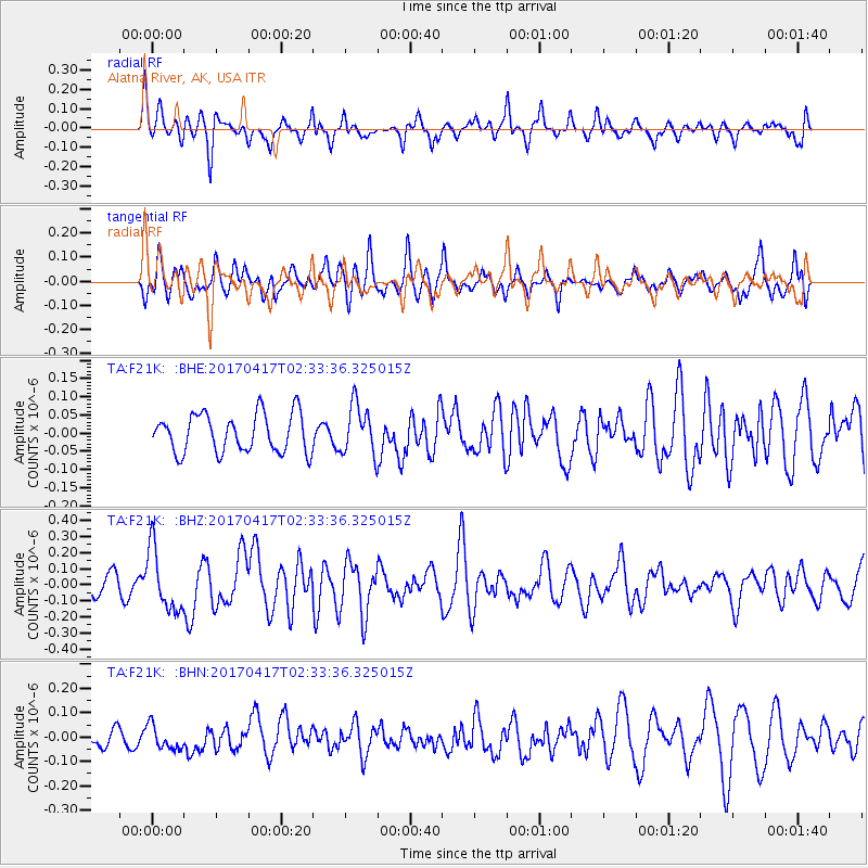
F21K Alatna River, AK, USA - Earthquake Result Viewer
*The percent match for this event was below the threshold and hence no stack was calculated.
| Earthquake location: |
Vanuatu Islands |
| Earthquake latitude/longitude: |
-13.4/166.5 |
| Earthquake time(UTC): |
2017/04/17 (107) 02:21:32 GMT |
| Earthquake Depth: |
20 km |
| Earthquake Magnitude: |
5.7 Mww |
| Earthquake Catalog/Contributor: |
NEIC PDE/us |
|
| Network: |
TA USArray Transportable Network (new EarthScope stations) |
| Station: |
F21K Alatna River, AK, USA |
| Lat/Lon: |
67.22 N/153.48 W |
| Elevation: |
597 m |
|
| Distance: |
85.5 deg |
| Az: |
14.534 deg |
| Baz: |
218.845 deg |
| Ray Param: |
$rayparam |
*The percent match for this event was below the threshold and hence was not used in the summary stack. |
|
| Radial Match: |
70.38157 % |
| Radial Bump: |
400 |
| Transverse Match: |
69.16954 % |
| Transverse Bump: |
400 |
| SOD ConfigId: |
11737051 |
| Insert Time: |
2019-04-27 03:08:15.749 +0000 |
| GWidth: |
2.5 |
| Max Bumps: |
400 |
| Tol: |
0.001 |
|
Signal To Noise
| Channel | StoN | STA | LTA |
| TA:F21K: :BHZ:20170417T02:33:36.325015Z | 2.8912756 | 1.9220276E-7 | 6.64768E-8 |
| TA:F21K: :BHN:20170417T02:33:36.325015Z | 1.0380322 | 4.9873353E-8 | 4.8046058E-8 |
| TA:F21K: :BHE:20170417T02:33:36.325015Z | 1.3560287 | 7.160061E-8 | 5.2801695E-8 |
| Arrivals |
| Ps | |
| PpPs | |
| PsPs/PpSs | |


