You are here: Home > Network List > TA - USArray Transportable Network (new EarthScope stations) Stations List
> Station O12A Currie, NV, USA > Earthquake Result Viewer
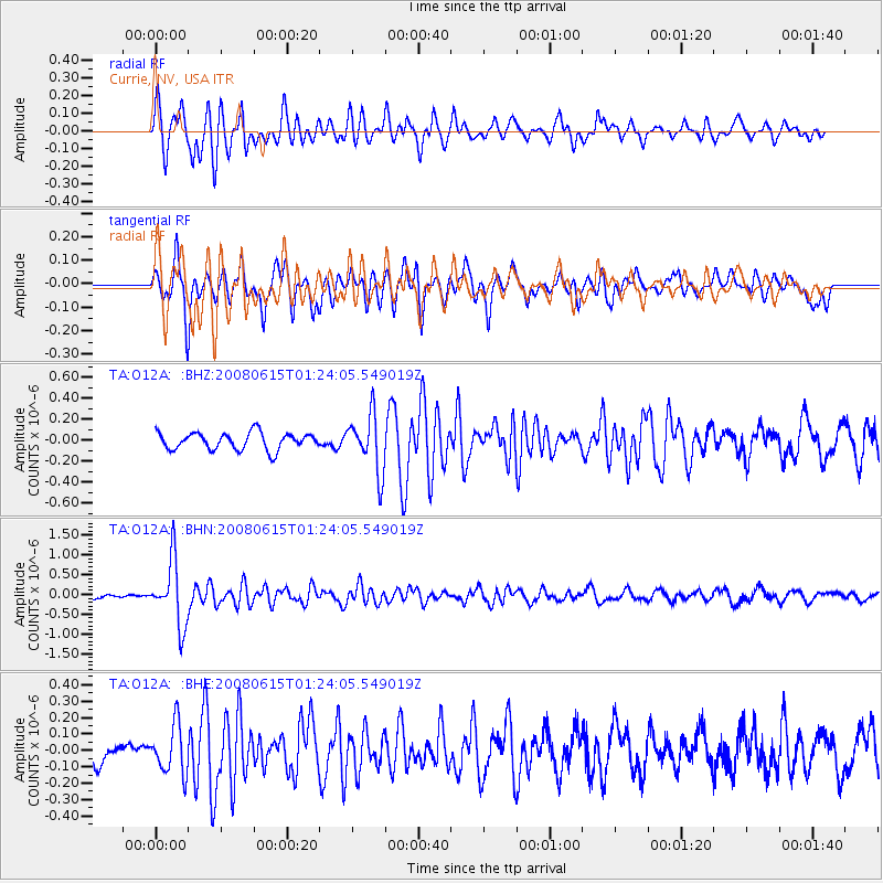
O12A Currie, NV, USA - Earthquake Result Viewer
*The percent match for this event was below the threshold and hence no stack was calculated.
| Earthquake location: |
Fiji Islands Region |
| Earthquake latitude/longitude: |
-17.7/-179.7 |
| Earthquake time(UTC): |
2008/06/15 (167) 01:13:11 GMT |
| Earthquake Depth: |
611 km |
| Earthquake Magnitude: |
5.5 MB, 5.9 MW, 5.9 MW |
| Earthquake Catalog/Contributor: |
WHDF/NEIC |
|
| Network: |
TA USArray Transportable Network (new EarthScope stations) |
| Station: |
O12A Currie, NV, USA |
| Lat/Lon: |
40.27 N/114.75 W |
| Elevation: |
1743 m |
|
| Distance: |
83.5 deg |
| Az: |
44.259 deg |
| Baz: |
240.376 deg |
| Ray Param: |
$rayparam |
*The percent match for this event was below the threshold and hence was not used in the summary stack. |
|
| Radial Match: |
77.34586 % |
| Radial Bump: |
400 |
| Transverse Match: |
76.42318 % |
| Transverse Bump: |
400 |
| SOD ConfigId: |
2504 |
| Insert Time: |
2010-03-05 23:04:05.543 +0000 |
| GWidth: |
2.5 |
| Max Bumps: |
400 |
| Tol: |
0.001 |
|
Signal To Noise
| Channel | StoN | STA | LTA |
| TA:O12A: :BHN:20080615T01:24:05.549019Z | 11.988536 | 8.106927E-7 | 6.762233E-8 |
| TA:O12A: :BHE:20080615T01:24:05.549019Z | 2.2727313 | 1.4952589E-7 | 6.5791276E-8 |
| TA:O12A: :BHZ:20080615T01:24:05.549019Z | 3.350994 | 2.7206588E-7 | 8.1189604E-8 |
| Arrivals |
| Ps | |
| PpPs | |
| PsPs/PpSs | |


