You are here: Home > Network List > AK - Alaska Regional Network Stations List
> Station GAMB Gambell Broadband > Earthquake Result Viewer
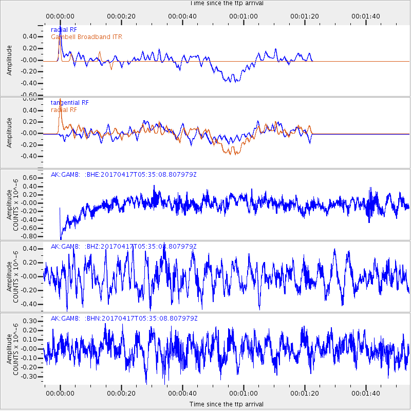
GAMB Gambell Broadband - Earthquake Result Viewer
*The percent match for this event was below the threshold and hence no stack was calculated.
| Earthquake location: |
Leeward Islands |
| Earthquake latitude/longitude: |
17.5/-61.1 |
| Earthquake time(UTC): |
2017/04/17 (107) 05:23:15 GMT |
| Earthquake Depth: |
21 km |
| Earthquake Magnitude: |
5.6 Mww |
| Earthquake Catalog/Contributor: |
NEIC PDE/us |
|
| Network: |
AK Alaska Regional Network |
| Station: |
GAMB Gambell Broadband |
| Lat/Lon: |
63.78 N/171.70 W |
| Elevation: |
10 m |
|
| Distance: |
83.2 deg |
| Az: |
335.234 deg |
| Baz: |
64.152 deg |
| Ray Param: |
$rayparam |
*The percent match for this event was below the threshold and hence was not used in the summary stack. |
|
| Radial Match: |
33.597866 % |
| Radial Bump: |
400 |
| Transverse Match: |
35.742138 % |
| Transverse Bump: |
400 |
| SOD ConfigId: |
11737051 |
| Insert Time: |
2019-04-27 03:12:22.188 +0000 |
| GWidth: |
2.5 |
| Max Bumps: |
400 |
| Tol: |
0.001 |
|
Signal To Noise
| Channel | StoN | STA | LTA |
| AK:GAMB: :BHZ:20170417T05:35:08.807979Z | 2.5236752 | 1.9603033E-7 | 7.767653E-8 |
| AK:GAMB: :BHN:20170417T05:35:08.807979Z | 0.7541154 | 8.2348436E-8 | 1.0919872E-7 |
| AK:GAMB: :BHE:20170417T05:35:08.807979Z | 1.1729945 | 2.7348534E-7 | 2.3315143E-7 |
| Arrivals |
| Ps | |
| PpPs | |
| PsPs/PpSs | |


