You are here: Home > Network List > TA - USArray Transportable Network (new EarthScope stations) Stations List
> Station O12A Currie, NV, USA > Earthquake Result Viewer
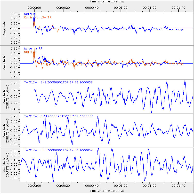
O12A Currie, NV, USA - Earthquake Result Viewer
*The percent match for this event was below the threshold and hence no stack was calculated.
| Earthquake location: |
Fiji Islands Region |
| Earthquake latitude/longitude: |
-15.3/-176.4 |
| Earthquake time(UTC): |
2008/09/01 (245) 07:06:16 GMT |
| Earthquake Depth: |
10 km |
| Earthquake Magnitude: |
5.6 MS, 5.4 MB, 5.7 MW, 5.7 MW |
| Earthquake Catalog/Contributor: |
WHDF/NEIC |
|
| Network: |
TA USArray Transportable Network (new EarthScope stations) |
| Station: |
O12A Currie, NV, USA |
| Lat/Lon: |
40.27 N/114.75 W |
| Elevation: |
1743 m |
|
| Distance: |
79.5 deg |
| Az: |
43.232 deg |
| Baz: |
239.769 deg |
| Ray Param: |
$rayparam |
*The percent match for this event was below the threshold and hence was not used in the summary stack. |
|
| Radial Match: |
78.89359 % |
| Radial Bump: |
353 |
| Transverse Match: |
69.915344 % |
| Transverse Bump: |
400 |
| SOD ConfigId: |
2504 |
| Insert Time: |
2010-03-05 23:04:33.548 +0000 |
| GWidth: |
2.5 |
| Max Bumps: |
400 |
| Tol: |
0.001 |
|
Signal To Noise
| Channel | StoN | STA | LTA |
| TA:O12A: :BHN:20080901T07:17:52.100005Z | 2.2738612 | 2.1742157E-7 | 9.5617786E-8 |
| TA:O12A: :BHE:20080901T07:17:52.100005Z | 1.6201038 | 1.5219291E-7 | 9.394022E-8 |
| TA:O12A: :BHZ:20080901T07:17:52.100005Z | 1.3871351 | 1.6285533E-7 | 1.17404085E-7 |
| Arrivals |
| Ps | |
| PpPs | |
| PsPs/PpSs | |


