You are here: Home > Network List > AV - Alaska Volcano Observatory Stations List
> Station SPCR Ckakachatna River, Mount Spurr, Alaska > Earthquake Result Viewer
SPCR Ckakachatna River, Mount Spurr, Alaska - Earthquake Result Viewer
*The percent match for this event was below the threshold and hence no stack was calculated.
| Earthquake location: |
Leeward Islands |
| Earthquake latitude/longitude: |
17.5/-61.1 |
| Earthquake time(UTC): |
2017/04/17 (107) 05:23:15 GMT |
| Earthquake Depth: |
21 km |
| Earthquake Magnitude: |
5.6 Mww |
| Earthquake Catalog/Contributor: |
NEIC PDE/us |
|
| Network: |
AV Alaska Volcano Observatory |
| Station: |
SPCR Ckakachatna River, Mount Spurr, Alaska |
| Lat/Lon: |
61.20 N/152.21 W |
| Elevation: |
984 m |
|
| Distance: |
75.4 deg |
| Az: |
329.976 deg |
| Baz: |
80.474 deg |
| Ray Param: |
$rayparam |
*The percent match for this event was below the threshold and hence was not used in the summary stack. |
|
| Radial Match: |
50.57815 % |
| Radial Bump: |
400 |
| Transverse Match: |
71.94837 % |
| Transverse Bump: |
400 |
| SOD ConfigId: |
11737051 |
| Insert Time: |
2019-04-27 03:13:03.967 +0000 |
| GWidth: |
2.5 |
| Max Bumps: |
400 |
| Tol: |
0.001 |
|
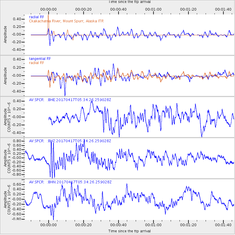
Signal To Noise
| Channel | StoN | STA | LTA |
| AV:SPCR: :BHZ:20170417T05:34:26.259028Z | 2.904534 | 5.31316E-7 | 1.8292641E-7 |
| AV:SPCR: :BHN:20170417T05:34:26.259028Z | 2.710887 | 4.0026407E-7 | 1.4765061E-7 |
| AV:SPCR: :BHE:20170417T05:34:26.259028Z | 1.4463266 | 1.7485671E-7 | 1.2089711E-7 |
| Arrivals |
| Ps | |
| PpPs | |
| PsPs/PpSs | |


