You are here: Home > Network List > AZ - ANZA Regional Network Stations List
> Station SMER AZ.SMER > Earthquake Result Viewer
SMER AZ.SMER - Earthquake Result Viewer
*The percent match for this event was below the threshold and hence no stack was calculated.
| Earthquake location: |
Leeward Islands |
| Earthquake latitude/longitude: |
17.5/-61.1 |
| Earthquake time(UTC): |
2017/04/17 (107) 05:23:15 GMT |
| Earthquake Depth: |
21 km |
| Earthquake Magnitude: |
5.6 Mww |
| Earthquake Catalog/Contributor: |
NEIC PDE/us |
|
| Network: |
AZ ANZA Regional Network |
| Station: |
SMER AZ.SMER |
| Lat/Lon: |
33.46 N/117.17 W |
| Elevation: |
355 m |
|
| Distance: |
52.4 deg |
| Az: |
299.0 deg |
| Baz: |
93.117 deg |
| Ray Param: |
$rayparam |
*The percent match for this event was below the threshold and hence was not used in the summary stack. |
|
| Radial Match: |
61.306667 % |
| Radial Bump: |
400 |
| Transverse Match: |
49.59296 % |
| Transverse Bump: |
400 |
| SOD ConfigId: |
11737051 |
| Insert Time: |
2019-04-27 03:13:11.819 +0000 |
| GWidth: |
2.5 |
| Max Bumps: |
400 |
| Tol: |
0.001 |
|
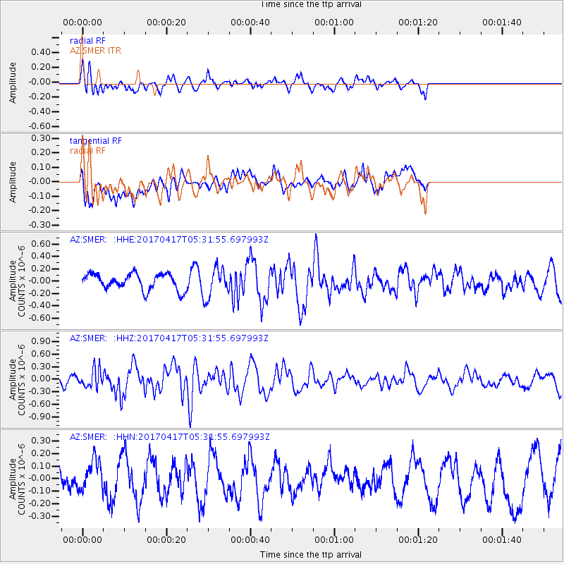
Signal To Noise
| Channel | StoN | STA | LTA |
| AZ:SMER: :HHZ:20170417T05:31:55.697993Z | 1.1242858 | 2.177635E-7 | 1.9369051E-7 |
| AZ:SMER: :HHN:20170417T05:31:55.697993Z | 1.2284223 | 1.277177E-7 | 1.0396889E-7 |
| AZ:SMER: :HHE:20170417T05:31:55.697993Z | 1.7999384 | 2.3291935E-7 | 1.2940407E-7 |
| Arrivals |
| Ps | |
| PpPs | |
| PsPs/PpSs | |


