You are here: Home > Network List > TA - USArray Transportable Network (new EarthScope stations) Stations List
> Station V29A Stinnett, TX, USA > Earthquake Result Viewer
V29A Stinnett, TX, USA - Earthquake Result Viewer
| Earthquake location: |
Tonga Islands |
| Earthquake latitude/longitude: |
-20.8/-174.3 |
| Earthquake time(UTC): |
2009/07/30 (211) 20:05:34 GMT |
| Earthquake Depth: |
10 km |
| Earthquake Magnitude: |
5.9 MB, 5.7 MS, 5.8 MW, 5.7 MW |
| Earthquake Catalog/Contributor: |
WHDF/NEIC |
|
| Network: |
TA USArray Transportable Network (new EarthScope stations) |
| Station: |
V29A Stinnett, TX, USA |
| Lat/Lon: |
35.87 N/101.52 W |
| Elevation: |
953 m |
|
| Distance: |
88.9 deg |
| Az: |
50.87 deg |
| Baz: |
243.294 deg |
| Ray Param: |
0.042237304 |
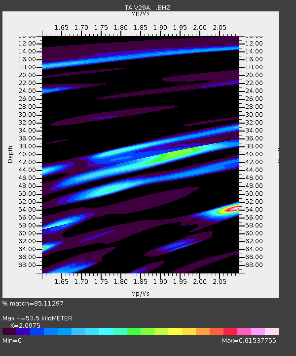
| Estimated Moho Depth: |
53.5 km |
| Estimated Crust Vp/Vs: |
2.10 |
| Assumed Crust Vp: |
6.426 km/s |
| Estimated Crust Vs: |
3.064 km/s |
| Estimated Crust Poisson's Ratio: |
0.35 |
|
| Radial Match: |
85.11297 % |
| Radial Bump: |
400 |
| Transverse Match: |
63.695335 % |
| Transverse Bump: |
400 |
| SOD ConfigId: |
2622 |
| Insert Time: |
2010-03-05 23:04:42.043 +0000 |
| GWidth: |
2.5 |
| Max Bumps: |
400 |
| Tol: |
0.001 |
|

Signal To Noise
| Channel | StoN | STA | LTA |
| TA:V29A: :BHZ:20090730T20:17:57.924021Z | 2.6630197 | 5.3366034E-7 | 2.0039668E-7 |
| TA:V29A: :BHN:20090730T20:17:57.924021Z | 1.1844234 | 1.3260225E-7 | 1.119551E-7 |
| TA:V29A: :BHE:20090730T20:17:57.924021Z | 1.617589 | 2.0569009E-7 | 1.2715843E-7 |
| Arrivals |
| Ps | 9.3 SECOND |
| PpPs | 25 SECOND |
| PsPs/PpSs | 35 SECOND |


