You are here: Home > Network List > CI - Caltech Regional Seismic Network Stations List
> Station MPM Manuel Prospect Mine, California, USA > Earthquake Result Viewer
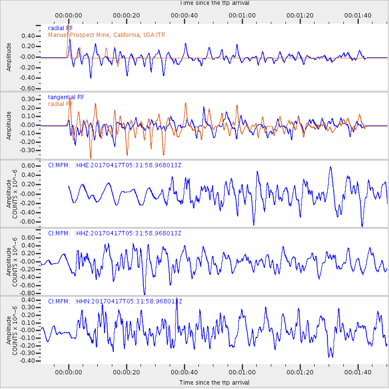
MPM Manuel Prospect Mine, California, USA - Earthquake Result Viewer
*The percent match for this event was below the threshold and hence no stack was calculated.
| Earthquake location: |
Leeward Islands |
| Earthquake latitude/longitude: |
17.5/-61.1 |
| Earthquake time(UTC): |
2017/04/17 (107) 05:23:15 GMT |
| Earthquake Depth: |
21 km |
| Earthquake Magnitude: |
5.6 Mww |
| Earthquake Catalog/Contributor: |
NEIC PDE/us |
|
| Network: |
CI Caltech Regional Seismic Network |
| Station: |
MPM Manuel Prospect Mine, California, USA |
| Lat/Lon: |
36.06 N/117.49 W |
| Elevation: |
185 m |
|
| Distance: |
52.9 deg |
| Az: |
302.232 deg |
| Baz: |
94.897 deg |
| Ray Param: |
$rayparam |
*The percent match for this event was below the threshold and hence was not used in the summary stack. |
|
| Radial Match: |
65.87044 % |
| Radial Bump: |
400 |
| Transverse Match: |
62.921894 % |
| Transverse Bump: |
400 |
| SOD ConfigId: |
11737051 |
| Insert Time: |
2019-04-27 03:14:28.948 +0000 |
| GWidth: |
2.5 |
| Max Bumps: |
400 |
| Tol: |
0.001 |
|
Signal To Noise
| Channel | StoN | STA | LTA |
| CI:MPM: :HHZ:20170417T05:31:58.968013Z | 3.4136894 | 1.9696999E-7 | 5.770003E-8 |
| CI:MPM: :HHN:20170417T05:31:58.968013Z | 1.1340938 | 1.14046514E-7 | 1.00561806E-7 |
| CI:MPM: :HHE:20170417T05:31:58.968013Z | 0.8176172 | 1.0126332E-7 | 1.2385175E-7 |
| Arrivals |
| Ps | |
| PpPs | |
| PsPs/PpSs | |


