You are here: Home > Network List > IW - Intermountain West Stations List
> Station MFID Camas Ranch, Mayfield, ID, USA > Earthquake Result Viewer
MFID Camas Ranch, Mayfield, ID, USA - Earthquake Result Viewer
| Earthquake location: |
Peru-Brazil Border Region |
| Earthquake latitude/longitude: |
-10.6/-71.0 |
| Earthquake time(UTC): |
2015/11/24 (328) 22:45:38 GMT |
| Earthquake Depth: |
602 km |
| Earthquake Magnitude: |
7.5 MWW, 6.9 MI |
| Earthquake Catalog/Contributor: |
NEIC PDE/NEIC COMCAT |
|
| Network: |
IW Intermountain West |
| Station: |
MFID Camas Ranch, Mayfield, ID, USA |
| Lat/Lon: |
43.42 N/115.83 W |
| Elevation: |
1302 m |
|
| Distance: |
67.5 deg |
| Az: |
326.192 deg |
| Baz: |
131.344 deg |
| Ray Param: |
0.05474143 |
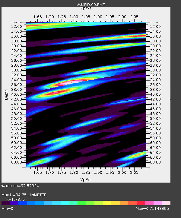
| Estimated Moho Depth: |
34.75 km |
| Estimated Crust Vp/Vs: |
1.79 |
| Assumed Crust Vp: |
6.291 km/s |
| Estimated Crust Vs: |
3.52 km/s |
| Estimated Crust Poisson's Ratio: |
0.27 |
|
| Radial Match: |
97.57924 % |
| Radial Bump: |
400 |
| Transverse Match: |
95.64566 % |
| Transverse Bump: |
400 |
| SOD ConfigId: |
1259291 |
| Insert Time: |
2015-12-08 23:39:01.795 +0000 |
| GWidth: |
2.5 |
| Max Bumps: |
400 |
| Tol: |
0.001 |
|

Signal To Noise
| Channel | StoN | STA | LTA |
| IW:MFID:00:BHZ:20151124T22:55:04.648989Z | 73.855835 | 2.0636506E-5 | 2.7941604E-7 |
| IW:MFID:00:BH1:20151124T22:55:04.648989Z | 12.318706 | 5.631617E-6 | 4.5715979E-7 |
| IW:MFID:00:BH2:20151124T22:55:04.648989Z | 28.701185 | 5.875692E-6 | 2.0471947E-7 |
| Arrivals |
| Ps | 4.5 SECOND |
| PpPs | 15 SECOND |
| PsPs/PpSs | 19 SECOND |


