You are here: Home > Network List > TA - USArray Transportable Network (new EarthScope stations) Stations List
> Station V29A Stinnett, TX, USA > Earthquake Result Viewer
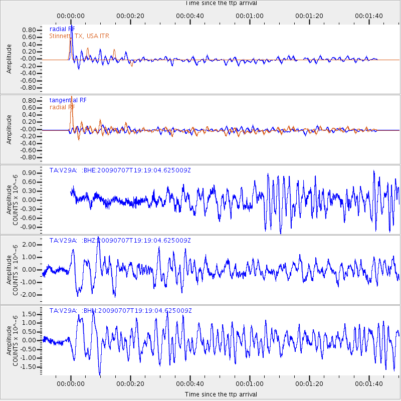
V29A Stinnett, TX, USA - Earthquake Result Viewer
| Earthquake location: |
Baffin Bay |
| Earthquake latitude/longitude: |
75.4/-72.5 |
| Earthquake time(UTC): |
2009/07/07 (188) 19:11:46 GMT |
| Earthquake Depth: |
19 km |
| Earthquake Magnitude: |
5.9 MB, 5.7 MS, 6.1 MW, 6.0 MW |
| Earthquake Catalog/Contributor: |
WHDF/NEIC |
|
| Network: |
TA USArray Transportable Network (new EarthScope stations) |
| Station: |
V29A Stinnett, TX, USA |
| Lat/Lon: |
35.87 N/101.52 W |
| Elevation: |
953 m |
|
| Distance: |
41.9 deg |
| Az: |
216.256 deg |
| Baz: |
10.679 deg |
| Ray Param: |
0.0735041 |
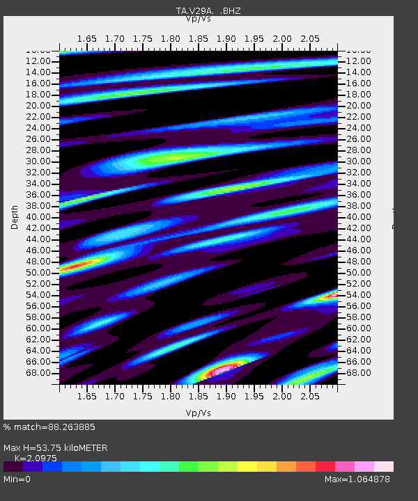
| Estimated Moho Depth: |
53.75 km |
| Estimated Crust Vp/Vs: |
2.10 |
| Assumed Crust Vp: |
6.426 km/s |
| Estimated Crust Vs: |
3.064 km/s |
| Estimated Crust Poisson's Ratio: |
0.35 |
|
| Radial Match: |
88.263885 % |
| Radial Bump: |
400 |
| Transverse Match: |
69.039925 % |
| Transverse Bump: |
400 |
| SOD ConfigId: |
2648 |
| Insert Time: |
2010-03-05 23:05:16.119 +0000 |
| GWidth: |
2.5 |
| Max Bumps: |
400 |
| Tol: |
0.001 |
|
Signal To Noise
| Channel | StoN | STA | LTA |
| TA:V29A: :BHZ:20090707T19:19:04.625009Z | 5.7891903 | 1.1803844E-6 | 2.0389456E-7 |
| TA:V29A: :BHN:20090707T19:19:04.625009Z | 5.3538194 | 8.6958926E-7 | 1.6242409E-7 |
| TA:V29A: :BHE:20090707T19:19:04.625009Z | 1.3504571 | 1.6970601E-7 | 1.2566562E-7 |
| Arrivals |
| Ps | 9.7 SECOND |
| PpPs | 24 SECOND |
| PsPs/PpSs | 34 SECOND |


