You are here: Home > Network List > TA - USArray Transportable Network (new EarthScope stations) Stations List
> Station V29A Stinnett, TX, USA > Earthquake Result Viewer
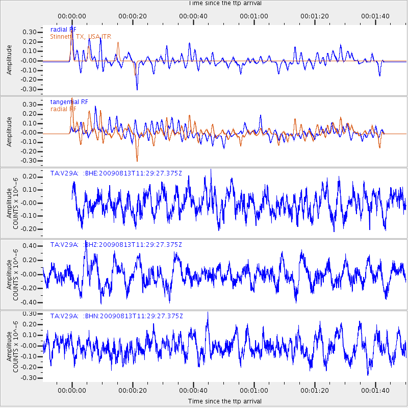
V29A Stinnett, TX, USA - Earthquake Result Viewer
*The percent match for this event was below the threshold and hence no stack was calculated.
| Earthquake location: |
Tonga Islands |
| Earthquake latitude/longitude: |
-21.7/-174.6 |
| Earthquake time(UTC): |
2009/08/13 (225) 11:17:01 GMT |
| Earthquake Depth: |
10 km |
| Earthquake Magnitude: |
5.6 MW, 5.3 MB |
| Earthquake Catalog/Contributor: |
WHDF/NEIC |
|
| Network: |
TA USArray Transportable Network (new EarthScope stations) |
| Station: |
V29A Stinnett, TX, USA |
| Lat/Lon: |
35.87 N/101.52 W |
| Elevation: |
953 m |
|
| Distance: |
89.6 deg |
| Az: |
50.976 deg |
| Baz: |
242.849 deg |
| Ray Param: |
$rayparam |
*The percent match for this event was below the threshold and hence was not used in the summary stack. |
|
| Radial Match: |
66.22436 % |
| Radial Bump: |
400 |
| Transverse Match: |
57.746017 % |
| Transverse Bump: |
400 |
| SOD ConfigId: |
2622 |
| Insert Time: |
2010-03-05 23:05:27.793 +0000 |
| GWidth: |
2.5 |
| Max Bumps: |
400 |
| Tol: |
0.001 |
|
Signal To Noise
| Channel | StoN | STA | LTA |
| TA:V29A: :BHZ:20090813T11:29:27.375Z | 2.582935 | 1.9779061E-7 | 7.657591E-8 |
| TA:V29A: :BHN:20090813T11:29:27.375Z | 0.862368 | 7.21326E-8 | 8.364481E-8 |
| TA:V29A: :BHE:20090813T11:29:27.375Z | 1.2974286 | 9.1262294E-8 | 7.0340896E-8 |
| Arrivals |
| Ps | |
| PpPs | |
| PsPs/PpSs | |


