You are here: Home > Network List > NE - New England Seismic Network Stations List
> Station BRYW Smithfield, RI, USA > Earthquake Result Viewer
BRYW Smithfield, RI, USA - Earthquake Result Viewer
| Earthquake location: |
Peru-Brazil Border Region |
| Earthquake latitude/longitude: |
-10.6/-71.0 |
| Earthquake time(UTC): |
2015/11/24 (328) 22:45:38 GMT |
| Earthquake Depth: |
602 km |
| Earthquake Magnitude: |
7.5 MWW, 6.9 MI |
| Earthquake Catalog/Contributor: |
NEIC PDE/NEIC COMCAT |
|
| Network: |
NE New England Seismic Network |
| Station: |
BRYW Smithfield, RI, USA |
| Lat/Lon: |
41.92 N/71.54 W |
| Elevation: |
116 m |
|
| Distance: |
52.2 deg |
| Az: |
359.46 deg |
| Baz: |
179.288 deg |
| Ray Param: |
0.06414431 |
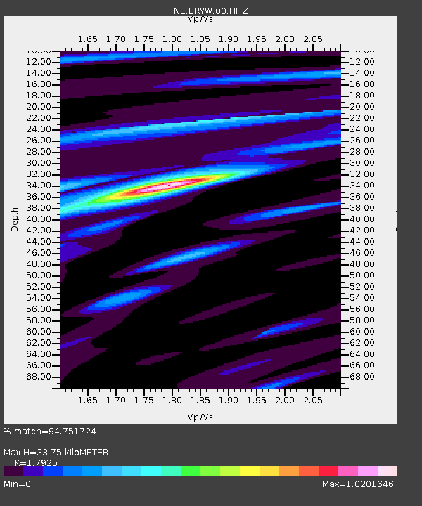
| Estimated Moho Depth: |
33.75 km |
| Estimated Crust Vp/Vs: |
1.79 |
| Assumed Crust Vp: |
6.472 km/s |
| Estimated Crust Vs: |
3.611 km/s |
| Estimated Crust Poisson's Ratio: |
0.27 |
|
| Radial Match: |
94.751724 % |
| Radial Bump: |
325 |
| Transverse Match: |
78.074684 % |
| Transverse Bump: |
400 |
| SOD ConfigId: |
1259291 |
| Insert Time: |
2015-12-08 23:39:56.156 +0000 |
| GWidth: |
2.5 |
| Max Bumps: |
400 |
| Tol: |
0.001 |
|

Signal To Noise
| Channel | StoN | STA | LTA |
| NE:BRYW:00:HHZ:20151124T22:53:24.183993Z | 17.455072 | 1.2906398E-5 | 7.3940674E-7 |
| NE:BRYW:00:HH1:20151124T22:53:24.183993Z | 9.172188 | 6.6184834E-6 | 7.215818E-7 |
| NE:BRYW:00:HH2:20151124T22:53:24.183993Z | 2.6210153 | 1.5007555E-6 | 5.725855E-7 |
| Arrivals |
| Ps | 4.3 SECOND |
| PpPs | 14 SECOND |
| PsPs/PpSs | 18 SECOND |


