You are here: Home > Network List > TA - USArray Transportable Network (new EarthScope stations) Stations List
> Station A36M Sachs Harbour, NT, CAN > Earthquake Result Viewer
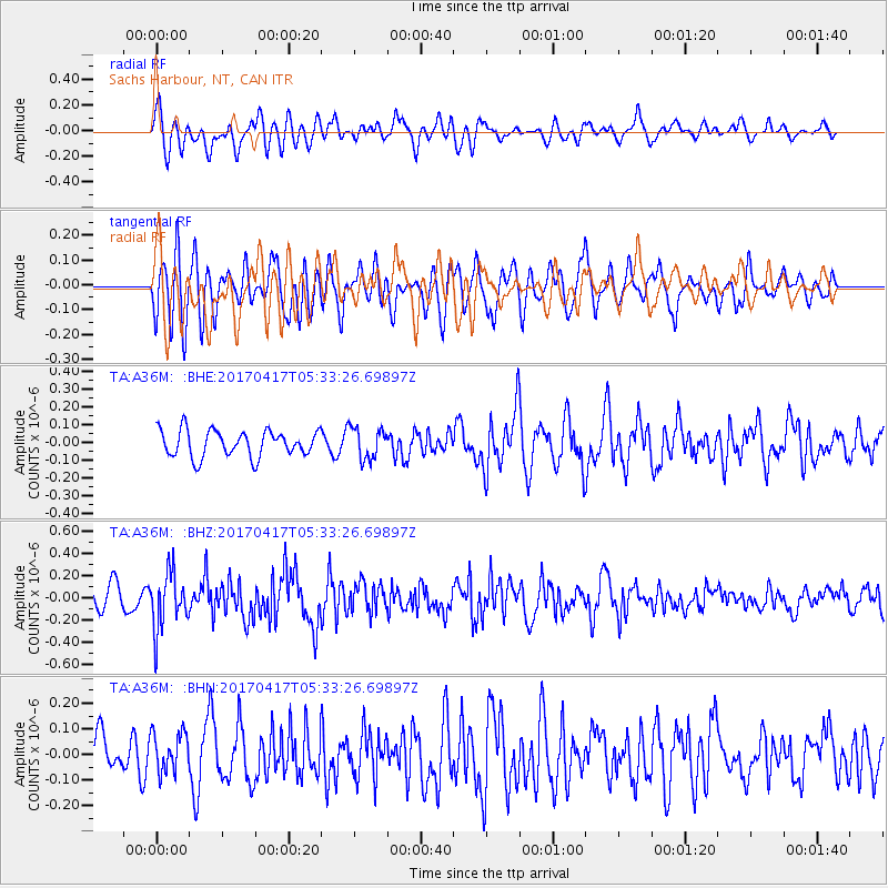
A36M Sachs Harbour, NT, CAN - Earthquake Result Viewer
*The percent match for this event was below the threshold and hence no stack was calculated.
| Earthquake location: |
Leeward Islands |
| Earthquake latitude/longitude: |
17.5/-61.1 |
| Earthquake time(UTC): |
2017/04/17 (107) 05:23:15 GMT |
| Earthquake Depth: |
21 km |
| Earthquake Magnitude: |
5.6 Mww |
| Earthquake Catalog/Contributor: |
NEIC PDE/us |
|
| Network: |
TA USArray Transportable Network (new EarthScope stations) |
| Station: |
A36M Sachs Harbour, NT, CAN |
| Lat/Lon: |
71.99 N/125.25 W |
| Elevation: |
32 m |
|
| Distance: |
65.6 deg |
| Az: |
342.099 deg |
| Baz: |
109.451 deg |
| Ray Param: |
$rayparam |
*The percent match for this event was below the threshold and hence was not used in the summary stack. |
|
| Radial Match: |
69.49383 % |
| Radial Bump: |
400 |
| Transverse Match: |
66.57202 % |
| Transverse Bump: |
400 |
| SOD ConfigId: |
11737051 |
| Insert Time: |
2019-04-27 03:19:24.457 +0000 |
| GWidth: |
2.5 |
| Max Bumps: |
400 |
| Tol: |
0.001 |
|
Signal To Noise
| Channel | StoN | STA | LTA |
| TA:A36M: :BHZ:20170417T05:33:26.69897Z | 2.8305802 | 2.5170303E-7 | 8.892277E-8 |
| TA:A36M: :BHN:20170417T05:33:26.69897Z | 1.1442522 | 7.7637104E-8 | 6.784965E-8 |
| TA:A36M: :BHE:20170417T05:33:26.69897Z | 1.2045127 | 8.9497654E-8 | 7.430195E-8 |
| Arrivals |
| Ps | |
| PpPs | |
| PsPs/PpSs | |


