You are here: Home > Network List > TA - USArray Transportable Network (new EarthScope stations) Stations List
> Station D25K Kavik River, AK, USA > Earthquake Result Viewer
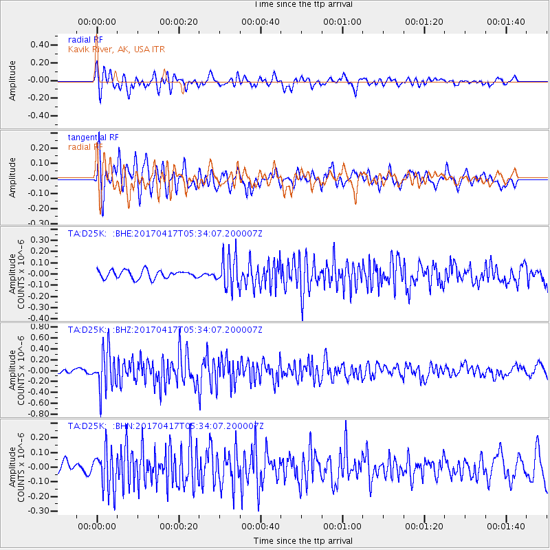
D25K Kavik River, AK, USA - Earthquake Result Viewer
*The percent match for this event was below the threshold and hence no stack was calculated.
| Earthquake location: |
Leeward Islands |
| Earthquake latitude/longitude: |
17.5/-61.1 |
| Earthquake time(UTC): |
2017/04/17 (107) 05:23:15 GMT |
| Earthquake Depth: |
21 km |
| Earthquake Magnitude: |
5.6 Mww |
| Earthquake Catalog/Contributor: |
NEIC PDE/us |
|
| Network: |
TA USArray Transportable Network (new EarthScope stations) |
| Station: |
D25K Kavik River, AK, USA |
| Lat/Lon: |
69.32 N/146.38 W |
| Elevation: |
770 m |
|
| Distance: |
72.1 deg |
| Az: |
338.164 deg |
| Baz: |
88.077 deg |
| Ray Param: |
$rayparam |
*The percent match for this event was below the threshold and hence was not used in the summary stack. |
|
| Radial Match: |
76.00854 % |
| Radial Bump: |
400 |
| Transverse Match: |
71.54989 % |
| Transverse Bump: |
400 |
| SOD ConfigId: |
11737051 |
| Insert Time: |
2019-04-27 03:19:31.776 +0000 |
| GWidth: |
2.5 |
| Max Bumps: |
400 |
| Tol: |
0.001 |
|
Signal To Noise
| Channel | StoN | STA | LTA |
| TA:D25K: :BHZ:20170417T05:34:07.200007Z | 7.2626324 | 3.6151678E-7 | 4.977765E-8 |
| TA:D25K: :BHN:20170417T05:34:07.200007Z | 3.0758326 | 1.3748037E-7 | 4.469696E-8 |
| TA:D25K: :BHE:20170417T05:34:07.200007Z | 3.9102137 | 1.3862466E-7 | 3.5451936E-8 |
| Arrivals |
| Ps | |
| PpPs | |
| PsPs/PpSs | |


