You are here: Home > Network List > TA - USArray Transportable Network (new EarthScope stations) Stations List
> Station L19K White Mountain, AK, USA > Earthquake Result Viewer
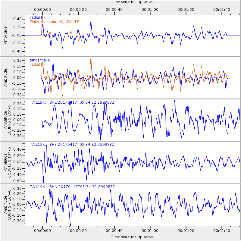
L19K White Mountain, AK, USA - Earthquake Result Viewer
*The percent match for this event was below the threshold and hence no stack was calculated.
| Earthquake location: |
Leeward Islands |
| Earthquake latitude/longitude: |
17.5/-61.1 |
| Earthquake time(UTC): |
2017/04/17 (107) 05:23:15 GMT |
| Earthquake Depth: |
21 km |
| Earthquake Magnitude: |
5.6 Mww |
| Earthquake Catalog/Contributor: |
NEIC PDE/us |
|
| Network: |
TA USArray Transportable Network (new EarthScope stations) |
| Station: |
L19K White Mountain, AK, USA |
| Lat/Lon: |
62.18 N/154.85 W |
| Elevation: |
650 m |
|
| Distance: |
76.4 deg |
| Az: |
331.212 deg |
| Baz: |
78.45 deg |
| Ray Param: |
$rayparam |
*The percent match for this event was below the threshold and hence was not used in the summary stack. |
|
| Radial Match: |
53.261673 % |
| Radial Bump: |
400 |
| Transverse Match: |
59.505863 % |
| Transverse Bump: |
400 |
| SOD ConfigId: |
11737051 |
| Insert Time: |
2019-04-27 03:19:54.933 +0000 |
| GWidth: |
2.5 |
| Max Bumps: |
400 |
| Tol: |
0.001 |
|
Signal To Noise
| Channel | StoN | STA | LTA |
| TA:L19K: :BHZ:20170417T05:34:32.299983Z | 2.7231038 | 2.446855E-7 | 8.985537E-8 |
| TA:L19K: :BHN:20170417T05:34:32.299983Z | 1.765155 | 1.5151325E-7 | 8.5835666E-8 |
| TA:L19K: :BHE:20170417T05:34:32.299983Z | 1.3868018 | 2.0025142E-7 | 1.44398E-7 |
| Arrivals |
| Ps | |
| PpPs | |
| PsPs/PpSs | |


