You are here: Home > Network List > NM - Cooperative New Madrid Seismic Network Stations List
> Station FFIL Fairfield, IL > Earthquake Result Viewer
FFIL Fairfield, IL - Earthquake Result Viewer
| Earthquake location: |
Peru-Brazil Border Region |
| Earthquake latitude/longitude: |
-10.6/-71.0 |
| Earthquake time(UTC): |
2015/11/24 (328) 22:45:38 GMT |
| Earthquake Depth: |
602 km |
| Earthquake Magnitude: |
7.5 MWW, 6.9 MI |
| Earthquake Catalog/Contributor: |
NEIC PDE/NEIC COMCAT |
|
| Network: |
NM Cooperative New Madrid Seismic Network |
| Station: |
FFIL Fairfield, IL |
| Lat/Lon: |
38.38 N/88.39 W |
| Elevation: |
446 m |
|
| Distance: |
51.4 deg |
| Az: |
342.465 deg |
| Baz: |
157.857 deg |
| Ray Param: |
0.064682215 |
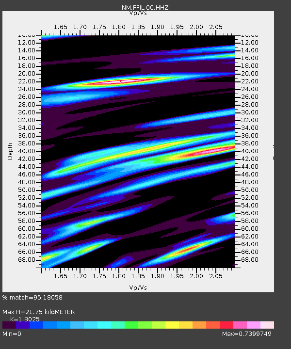
| Estimated Moho Depth: |
21.75 km |
| Estimated Crust Vp/Vs: |
1.80 |
| Assumed Crust Vp: |
6.444 km/s |
| Estimated Crust Vs: |
3.575 km/s |
| Estimated Crust Poisson's Ratio: |
0.28 |
|
| Radial Match: |
95.18058 % |
| Radial Bump: |
400 |
| Transverse Match: |
87.81619 % |
| Transverse Bump: |
400 |
| SOD ConfigId: |
1259291 |
| Insert Time: |
2015-12-08 23:41:15.611 +0000 |
| GWidth: |
2.5 |
| Max Bumps: |
400 |
| Tol: |
0.001 |
|

Signal To Noise
| Channel | StoN | STA | LTA |
| NM:FFIL:00:HHZ:20151124T22:53:17.859011Z | 52.13485 | 2.6171587E-5 | 5.0199793E-7 |
| NM:FFIL:00:HHN:20151124T22:53:17.859011Z | 17.487011 | 1.115182E-5 | 6.377202E-7 |
| NM:FFIL:00:HHE:20151124T22:53:17.859011Z | 9.88153 | 4.658982E-6 | 4.7148387E-7 |
| Arrivals |
| Ps | 2.9 SECOND |
| PpPs | 9.0 SECOND |
| PsPs/PpSs | 12 SECOND |


