You are here: Home > Network List > UW - Pacific Northwest Regional Seismic Network Stations List
> Station LEBA Lebam, WA, USA > Earthquake Result Viewer
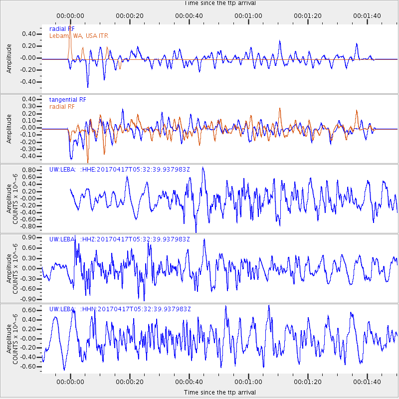
LEBA Lebam, WA, USA - Earthquake Result Viewer
*The percent match for this event was below the threshold and hence no stack was calculated.
| Earthquake location: |
Leeward Islands |
| Earthquake latitude/longitude: |
17.5/-61.1 |
| Earthquake time(UTC): |
2017/04/17 (107) 05:23:15 GMT |
| Earthquake Depth: |
21 km |
| Earthquake Magnitude: |
5.6 Mww |
| Earthquake Catalog/Contributor: |
NEIC PDE/us |
|
| Network: |
UW Pacific Northwest Regional Seismic Network |
| Station: |
LEBA Lebam, WA, USA |
| Lat/Lon: |
46.55 N/123.56 W |
| Elevation: |
73 m |
|
| Distance: |
58.6 deg |
| Az: |
314.215 deg |
| Baz: |
97.654 deg |
| Ray Param: |
$rayparam |
*The percent match for this event was below the threshold and hence was not used in the summary stack. |
|
| Radial Match: |
50.157116 % |
| Radial Bump: |
400 |
| Transverse Match: |
60.598557 % |
| Transverse Bump: |
400 |
| SOD ConfigId: |
11737051 |
| Insert Time: |
2019-04-27 03:21:07.891 +0000 |
| GWidth: |
2.5 |
| Max Bumps: |
400 |
| Tol: |
0.001 |
|
Signal To Noise
| Channel | StoN | STA | LTA |
| UW:LEBA: :HHZ:20170417T05:32:39.937983Z | 2.003858 | 3.977248E-7 | 1.9847951E-7 |
| UW:LEBA: :HHN:20170417T05:32:39.937983Z | 1.6538959 | 3.6329607E-7 | 2.1966079E-7 |
| UW:LEBA: :HHE:20170417T05:32:39.937983Z | 0.65412974 | 1.4894407E-7 | 2.2769805E-7 |
| Arrivals |
| Ps | |
| PpPs | |
| PsPs/PpSs | |


